Saturday, March 8, 2008

You Work on Friday to Pay for Your Auto Dependence

Peter Newman is the person who gave us the term Automobile Dependence and has been an excellent fighter in the war against it. He also has been looking at density as it pertains to transit usage and walkability. What I like best about this interview in the Oregonian is that he refutes the myth and conservative talking point that planners and transit agencies are in search of the perfect city and ultimately want you to get rid of your car. I certainly don't advocate that as I own a car myself, but am lucky enough to use it very little.

Q: So you don't advocate some sort of wholesale getting rid of the automobile or that people will on a large scale in small or midsize cities not use cars at all?

A: No. The ideal city, I reject.

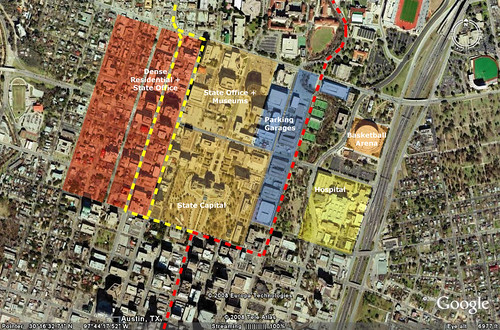
You can have carfree areas. I would say the city center of Portland is car free in that sense. There is a freedom from the car. You don't have to have a car there. You can live there, you can work there, in a way that enables you to have that freedom.

He also discusses the subsidies for automobiles that only recently have been gaining attention such as health care for auto accidents and big oil.

But to attack transit as being subsidized whilst not seeing the subsidies for car dependence is not a level playing field. We do those numbers in Australia, they're similar in America.

The politics is changing. We can no longer subsidize the increase in VMT - we have to subsidize the decrease in VMT. There is no choice in that.

And the kicker is he punches a hole in the freeway capacity issue. We've got to stop building wider freeways. He even suggests ripping them down like the Embarcadero or such as what should happen to the Viaduct in Seattle. I'm not sure if that is palatable for interstate highways but who am I to keep anyone from dreaming big. It's amazing how much tax base is taken away by these huge roads that move cars as fast as possible through cities instead of creating value.
Q: We have a $4 billion proposal to replace a six-lane highway bridge on Interstate 5 with a new bridge that would have six highway lanes, plus six auxiliary lanes. It would also extend light rail to the northern suburbs and have generous pedestrian facilities. It's been billed as having a little bit for everyone. Is that kind of project worth pursuing?

A: Four billion dollars is what you're going to need for building these transit lines and subcenters. Keeping the traffic moving is what you have to stop doing. VMT (vehicle miles traveled) reductions are not going to be promoted by that bridge. There will be a whole series of freeways taken down when they reach the end of their life in cities around the world. The one in Seoul (South Korea) came down. Now it's a beatiful river, and a park with transit. The mayor who did it is now the president.

Q: So increase rail transit, to the detriment of roads?

A: Any decent rail system can carry eight lanes of traffic equivalent - on this narrow little track. It's a capacity issue. You can only carry 2,500 people an hour down a freeway lane. You can get 50,000 an hour on a rail system - 20 times as much. That space is enormously valuable. There's no doubt in my mind that's what you've got to do.
This video is great. My favorite quote is when he states you are basically working one day a week to pay for your transport. I'm gonna make it Friday.

Thursday, March 6, 2008

Why the Line MUST Go Up Guadalupe Street

If what M1ek said in the comments of a previous post is true about the route for light rail in Austin being the Streetcar route that Capital Metro has put forth, they are making a really bad politically motivated move. I'm tired of Austin getting a raw deal from it's political deals and this is clearly a political deal with outgoing Republican Mike Krusee (just like the commuter rail line was) and the University of Texas, both of whom seem to not care about the needs of the population.

It's been stated before that Krusee plans to use the streetcar as a redevelopment tool to turn over some of the parking garages at the State into redevelopment opportunities. I'm all for redevelopment and streetcars as I've said before, but if this line gets built, they're risking possible expansion and political will by not building where people really want to go. There is one route that is a home run that will guaranty expansion...Guadalupe.

Here are 4 reasons why Austin needs to start light rail with the best starter light rail line possible

1. 1994 Denver - Built a very successful starter line and used that success to go after a 119 mile expansion plan

2. 1999 Salt Lake City - Opened North South Line connecting major destinations blowing out ridership projections. Recently passed a sales tax to build 5 new lines.

3. 2004 Houston - Built a starter line through the center of the two largest job centers in the city. Ridership is highest per mile of any new LRT line in the United States. 5 new lines are being planned and 2 are expected to be funded by the FTA later this year.

4. 2004 Minneapolis - Built Hiawatha line which exceeded 2025 projections. 30,000 riders and the DFL party just forwarded a bill that will give the region 8 corridors by 2020.

Let's take a look at how to do this in Austin because you don't often get a second chance.

Through the Capital Complex

Austin-DT Route

The red line is the "preferred alignment" by Capital Metro and the political backroom dealers. As you can see, the blue are parking garages and the red is existing dense development that is served by the most used bus corridor in the City (#1). Which one makes more sense? Go where the people are? or go where the cars are housed?

Through the University

Austin-UT Route

UT is one of the largest Universities in the country. There is a large concentration of students going to classes every day in the area I've labeled main university where the Guadalupe alignment should go. On the left side of the Guadalupe alignment, the West Campus area where the highest concentration of students live has just been rezoned for high density mixed use. Think the Pearl District and South Lake Union. The Back Room alignment goes by all of the facilities that people use perhaps 8-10 times a year. The swimming pool, the track, the stadium, the LBJ Library and the Bass Concert Hall. The problem is, people don't go there often from Downtown or from up North. The area east of the red alignment is generally dead space...I spent most of my time at UT running around that track and just outside its walls. Not too many people there.

Next we'll talk about the more northern options but lets do the first section right this time.

Tuesday, March 4, 2008

Two Views of Gentrification

There was an article in the Washington Post discussing the renaissance of Columbia Heights around the Metro Station. $1 Billion dollars worth of development is rising from the ground with apartments, shops, and the usual chain stores like Target the ubiquitous Bed Bath & Beyond. It's TOD at its best.

But the redevelopment with affordable housing we see as awesome is seen completely differently by a number of people around the country that see their neighborhoods change before their eyes. In a recent This American Life (if you don't listen I highly recommend it), there was a discussion about 'The Plan'. 'The Plan' theory is the idea that the white population of DC uses planning and backroom deals to get rid of the african american population; condemning their public schools and infrastructure while using the land to build condos and upscale shops. It's not just about the real estate market, but blatant intent.

It's interesting to see the Post article the day after listening to the podcast, mostly because of the stark differences in the views portrayed. The awesome redevelopment around transit versus the displacement of residents and a plan to dilute the population with whiteness such as sushi.

Located near the District's geographic center and bound by 16th Street and Georgia Avenue, Columbia Heights' disparate narratives play out on the neighborhood's Internet mailing list, in which one posting last month was headlined "Sushi Coming to Columbia Heights!" Another updated viewers about a late afternoon shooting.

Black residents made up just over half the neighborhood's population in the 2000 Census, although their share had declined since the previous count while the numbers of Hispanic and white people grew. From 2000 to 2005, home buyers' median income rose from $76,000 to $103,000, according to the Urban Institute .

I suggest listening to the podcast before reading the article, and seeing if you can spot the differences portrayed.

Monday, March 3, 2008

Discussions of a Massive NY Subway Expansion

Check out Second Avenue Sagas for the skinny.

Multiplied By $10 and Divided By Something Else

So after we pick a route, get city, county and Broward Metropolitan Planning Organization approval, if we don't get Congress to change the rules governing small transit grants, is this project still possible?

"It's still possible, yes," Smelley answered.

"Define possible," Ladd demanded. "10 percent? 80 percent?"

"Gee," the consultant answered. "I don't know how to do that." It boils down to The Wave's "cost effectiveness," Smelley said. He launched into a complicated equation involving "travel time saving hours" multiplied by $10 and divided by something else.
This is an actual newspaper quote from Fort Lauderdale. While the city didn't get a straight answer from "consultants" they also won't get a straight answer as to why the Feds won't fund it. But why is that? Because the FTA has been doing a slow bloodletting that no one really noticed until now. Every year there have been less and less projects entering the New Starts program. I'm getting the feeling there will be less projects if no one can coherently explain the process and then Ken Orski will get his way. He says there are no more new systems to be built. Well we know from the transit space race he is full of baloney.

And on a related note, why aren't we trying to design expensive projects. $50 million per mile for a downtown circulator is ridiculous. Don't consultants want to make more money? It's insane to me that they aren't trying to do what Kenosha did and build affordable systems. They are biting the hand that feeds them and screwing mobility and economic development in the process. The city shouldn't get off scott free though. They should have done their research and figured out what costs should be so they can do like Sacramento did in their streetcar design. Put a cap on the cost and design from there. Is it really so hard?

Sunday, March 2, 2008

Subway to the Sea Badge

SubwaySeaButton

In an earlier post I discussed blog support badges and listed some I'd like to see. I created one for the Subway to the Sea for kicks. Feel free to use it.

Level the Urban Playing Field

A blog I really like to check out is the Bellows. Today Ryan discusses a response to an article about equity in cities vs. suburbs by economist Ed Glaeser. I agree with what he and Ed are saying about cities having to pay for some of suburbanites negative externalities which to him include the urban poor and the car based lifestyle. (Side note: A related recent article that people should read is about the movement of McMansions to McSlums by Chris Leinberger in a recent issue of the Atlantic.)

Back to Ed though; Back during the industrial revolution who could blame people for wanting to get away from the black soot and overcrowding that made up cities. It's different now though and there are lots of rules that keep cities from being the slums they were before. But today, cities pay (or as some say export tax base) to the suburbs in the form of road subsidies versus before when streetcars and streetcar suburbs were funded by the people in those suburbs. This to me is the biggest force today that promotes and spreads real sprawl. There have been policies after WWII that accelerated it including the Federal Highway System and suburban lending practices but those now are more of the beginning of the inertia rather than what is happening now. Now pro-suburban policies include job subsidies and the expansion of roads instead of maintenance. Now let's level the playing field.

No region should receive special favors from the federal government; no city should get special treatment from Beacon Hill. But our cities deserve a level playing field. A level playing field requires that urbanites should not bear an undue burden of caring for the poor and that suburbanites should pay for the environmental costs of energy-intensive lifestyles.
Back to the Bellows, some don't think that we should level the playing field to cities but Ryan gives this response:

His follow-up point that we shouldn’t do things to benefit cities because those things will unfairly benefit the rich is dreadfully off the mark. Glaeser is saying that society as a whole would be more urban if we got rid of some of the distortions preventing such a change (by charging, say, for pollution and congestion externalities). His broader point is that this will make society as a whole better off. And yes, policies to make life better in cities will have the effect of making life better for people in cities, and possibly harder for those in suburbs. So what? If the world needs to reduce carbon emissions, then it’s going to be the case that people who have to cut back most on their emissions get hurt the most. The alternative is to continue to allow those folks to not have to pay for the damage they inflict on the rest of us.

We Want the Line Away from Dense Places

Even though the extension of the Gold Line from Pasadena to the east has not even begun construction, there is already talk of expansion to Ontario Airport. There is hope that this would take expansion pressure off of the region's main airport LAX. As of now the extension to Ontario has three alternative routes and local NIMBY's are already starting to show their colors including elected officials.

"The Gold Line will be another transportation mode available to residents, and it could help revitalize the downtown area, so it's a good thing for Upland, in a general sense," said Anthony La, the city's public works director.

"Upland's preferred alignment is the one with the least impacts to Upland," he said. "We want to know the interests of the community are protected."

Unfortunately for any city, the route with the least impacts is also usually the route that goes where no one wants to go or come from. Usually we would like these rail lines to go through the denser areas to help people get from here to there. But some believe otherwise:
Mahdi Aluzri, deputy city manager of Rancho Cucamonga, said his residents will not be fond of that option as it puts the line in the San Bernardino Associated Governments-owned right of way currently occupied by the city's newly completed popular bike path.

"It passes through a bunch of densely populated residential areas," Aluzri said of the route. "It would have a negative impact, and I expect that to come up in the community meeting."
Perhaps someone local can shed a little more light on this but it's getting more and more apparent that the biggest obstacle to building good transit is people not wanting the line to go where the people are located. In this instance it might not be a concern in that these last sections are just route options with perhaps one station, but if that station is located away from people then it doesn't really help ridership or development opportunities.

WMATA and Joint Development

The Washington Post has an article on the restructuring of the Joint Development (Read TOD) program at WMATA. This is good news in that they will look at better development around the stations rather than just building anything to get money. This should pay off long term.

Too often in the past, board members said yesterday, land around stations was sold mainly to raise cash. The new rules focus on increasing transit-oriented residential and commercial development to encourage Metro ridership and reduce automobile traffic. The Ballston corridor in Arlington and Columbia Heights and Gallery Place-Chinatown in the District are considered examples of successful transit-oriented development.