
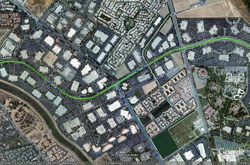
1. The Sprawl Way - What San Jose Looks Like
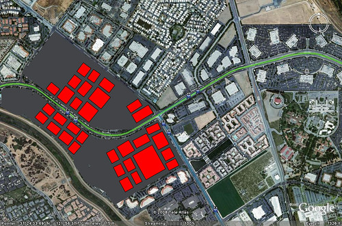
2. Sprawl Rearranged - What the same amount of development would look Like if the development were organized around the station. I outlined the buildings and rearranged them in a more compact way.
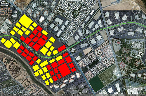
3. Sprawl Rearranged x2 - Doubling the amount of buildings, using the same footprint for each original building.
5 comments:
Not only can you fit twice as many buildings, but I bet that most of those buildings are about 3 stories tall, limited by the amount of surface parking that can be provided on the lot. You cold easily double or triple that, with either more office space or housing, for a total of six times the density, and probably a much nicer Silicon Valley.
This article in Canadian Geographic, http://www.canadiangeographic.ca/Magazine/ja05/alacarte.asp , describes better street patterns than the cul-de-sac that many suburbs have been building.
I thought that part of the idea of density is to shorten the distance from the transit stop. If you fill in those areas, then it becomes a long walk from the transit station again.
Part of the problems with those long walks is that they aren't very comfortable. In other words if you have a block grid system and the walk is made more pleasant by stores and windows etc then the walk won't seem as far. The walk from my house to BART is a half mile but it doesn't really feel that long because of good blocks.
A little late to the party. That looks like the lettered part of the Cisco campus (or at least the area near it - lettered buildings are west of 1st, numbered buildings are east). I worked in building 6 (or was it 7) for a few years. While that particular building was at the Cisco Way station, getting around campus without a car was terrible. An example - people would *drive* to get across the street to building 10. Why? Because you can only cross (safely) at the corners and the blocks are very long. Tasman is also very wide (5 lanes in each direction, if you include the turn lanes), plus enough width for three tracks of lightrail. If you're going from a midblock building to the midblock building across the street, you're looking at a 10-15 minute walk.
It seemed like a better layout would have been to cluster the buildings closer together at the street side, putting all the parking behind the buildings. Or better, have a narrow Tasman with local traffic only and put one way streets on the north and south sides of the campus with a few connecting streets (hmmm, just like an urban downtown...).
Post a Comment