
While I don't quibble with the need for expanded capacity on Riverside, I will argue that Guadalupe/Lamar is a superior route for urban rail in north of Austin's core, over a possible Highland corridor. I'll let others deal with the methodology issues in Project Connect's selection process, but for me, the data is clear that this corridor is superior for the following reasons...
While there are many laudable goals for building urban transit including housing and office development, the main reason for building a rail line is to increase the capacity of a road such that more people can get into a constrained space. Dan Chatman at the University of California at Berkeley and others have found that rail's key economic development benefit is serving to increase agglomeration effects in employment centers.
This is currently happening in the Warner Center in Los Angeles and Tyson's Corner in Virginia. The constraint to employment center growth is limits on auto access, so now landowners and policy makers introduce high capacity transit to get more people of all skill levels to their jobs and to increase the public and private productivity of the land.
This goal is in tandem to providing affordable housing, mixed income housing,
and reducing transportation costs but ultimately it is one of the main
reasons to build transit, to continue the increased benefits that
downtown's economic engine brings to the city and region as a whole
while giving more people access to those benefits.
So if the core is constrained, what is the best way to make travel easier to the most people such that they can reliably access jobs in the core as it grows? In other words, how do we feed more oxygen into the fire. Austin's current bus network does a good job of this, but certain corridors are constrained and need to be expanded. But you can't expand roads in those corridors so you need to expand the number of people who can travel in those corridors, hence high capacity transit.
So if the core is constrained, what is the best way to make travel easier to the most people such that they can reliably access jobs in the core as it grows? In other words, how do we feed more oxygen into the fire. Austin's current bus network does a good job of this, but certain corridors are constrained and need to be expanded. But you can't expand roads in those corridors so you need to expand the number of people who can travel in those corridors, hence high capacity transit.
2. RIDERSHIP
The answer to where you'll be able to pull the most oxygen to feed the fire is where they will be the most riders. Riders matter for two reasons, first it makes your line more cost effective from an operational standpoint. Currently the highest ridership bus line in the city by a long shot is the #1 on Guadalupe and Lamar. According to data from the service plan 2020 report, this corridor suffers the most in terms of on time performance. In fact that 2010 report noted that the bus was on time only 49% of the time!
The answer to where you'll be able to pull the most oxygen to feed the fire is where they will be the most riders. Riders matter for two reasons, first it makes your line more cost effective from an operational standpoint. Currently the highest ridership bus line in the city by a long shot is the #1 on Guadalupe and Lamar. According to data from the service plan 2020 report, this corridor suffers the most in terms of on time performance. In fact that 2010 report noted that the bus was on time only 49% of the time!
But the more riders you have on the line, the more you
can justify per passenger the operational cost. Portland has done a
great job with their light rail cost efficiency and has proved many
times that compared to the bus network, the light rail network is a more
efficient way of moving people in and out of downtown.
The second reason ridership matters is that if
you're going to be seeking funding from the FTA, you're also going to
be competing against every other region in the country seeking federal
funds. In the Transit Space Race report I noted that it would take 78
years to fund all the lines that are being planned with the current
federal funding levels of $1.6B per year. That number has actually been
lowered because of a stingy congress, but it's still a very small
number, especially when you're helping to build multi-billion dollar
subways in New York and San Francisco.
So what is the best way to win funding? In part its selling to the FTA that you have all your land use planning in place and have thought a bit about economic development. But they want to give a project justification rating, an overall rating, and you have to compete with lines like the LA downtown connector that are projecting 16,000 new trips out of 88,000 riders.
So what is the best way to win funding? In part its selling to the FTA that you have all your land use planning in place and have thought a bit about economic development. But they want to give a project justification rating, an overall rating, and you have to compete with lines like the LA downtown connector that are projecting 16,000 new trips out of 88,000 riders.
I highly recommend taking a look at other projects that are ahead of Austin in line for federal funds. Also, going back in time, the Austin line in 1999 scored very
high against places that are now built including Houston and the Twin
Cities - The Lamar line, which had pieces of the current Metro Rail line would have had 37,000 riders.
So what is the biggest thing that any light rail line can do to get more riders? Connect people with jobs.
3. THE IMPORTANCE OF JOBS
Connecting jobs with
transit drives ridership. We know this from research done by Zupan and
Pushkarev, Gary Barnes, and UC Berkeley's TOD guru Robert Cervero.
Considering over 59% of transit trips are for work, this becomes an
important point.
Pushkarev and Zupan in 1977's Public Transit and Land Use Policy - "Enlarging downtown size or raising nearby residential density. Suppose
the options are to double the size of a downtown from 10 to 20 million
square feet, or to double the residential density within a few miles of
it from 15 to 30 du/acre. The former will increase per capita trips by
transit three to four times more than the latter." Many more can be found in this post on the blog
This from Gary Barnes - "Using regression analysis, he showed that in Minneapolis, aside from
developing residential densities, transit share can be increased by
building up commercial centers. In the regression, he showed that for
every 1000 people per square mile that the residential density grew, the
increase in transit's share to downtown increased 2.4% versus .6%
increase when people went to suburban jobs."
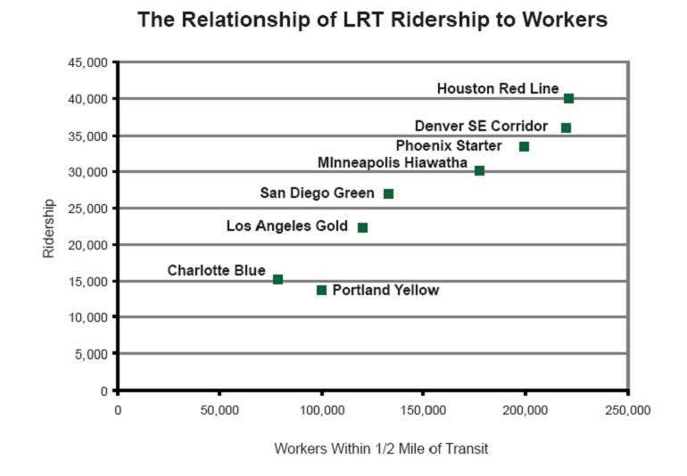
So what does this tell us? That trips increase when you connect places of density in a city to a strong downtown. But it's not just downtown that matters, it's all jobs along a line that build ridership. I created this chart below from my TRB paper on light rail ridership. It shows new light rail lines that were built in the last 10 years. What makes their ridership go up? Connections to jobs. Now in the paper I discuss many of the other issues that folks above mention as well including restricted parking downtown. But jobs seems to be a clear cut connection that's fairly easy to see, and backed up by a lot of the literature.
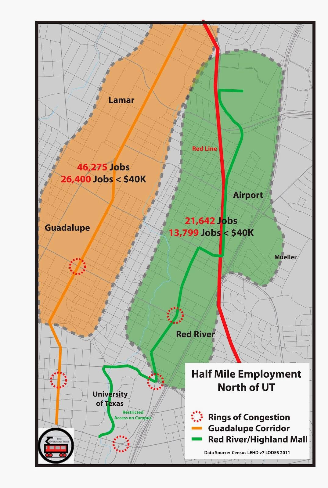
So jobs matter for ridership, and connecting more jobs within
a half mile of stations will get you more riders. So ignoring the core
of UT, Capital Complex and downtown, where are the most jobs outside of
downtown in the northern corridors that are being compared. Well of
course on the Guadalupe/Lamar corridor. This data was taken from the
2011 census LEHD dataset. The North Lamar corridor to Crestview has at
this present time 46,275 jobs within a half mile. 26,400 of them are
people making less than $40k annually. Contrast that with a likely
Highland Corridor, and you see less than half the number of jobs. Even
with rosy projections and development on that corridor, where would
25,000 jobs come from?
This
is part of the reason people are so upset at the process and
selection. Sure it's about congestion and redevelopment and serving low
income communities. But congestion is where the jobs are located. Redevelopment actually happens on light rail proximate to jobs as well.
4. WHERE DEVELOPMENT HAPPENS ON LIGHT RAIL
We
know this because CTOD did a study called Rails to Real Estate, which
looked at development patterns along three new light rail lines in
Charlotte, Denver, and Minneapolis. What this report says is that light
rail doesn't just create ridership out of thin air, a lot of public
policy has to take place but also that the market drives a significant
pattern of development.
There
are maps in the report that show where development happened along these
lines, but its best to describe it as the employment gravity well.
Basically the market for denser development is in major employment
centers, and that market gets extended from the gravity well by the rail
line. It's not just downtown because Denver's line connects the Tech
Center, which is the second largest employment cluster in the region,
and it saw an uptick in development as well. Take a look for yourself.
Alignments go away from downtown from left to right.
Twin Cities Hiawatha Line


Denver Southeast Corridor


Charlotte's South Corridor


This is obviously a small sample size of new lines but it
is quite instructive. The location of major employment drives
development and redevelopment because the transit is extending the
market, not creating it. Putting a line up into the Highland sector
might help spur a small catalyst of development, but its proximity to
downtown or a major employment center that matters most. Guadalupe and
Lamar have much more employment along the corridor which is likely to
give more people more options to connect with places they work and
places they want to go. But it's the straight line that matters a lot
too.
5. BE ON THE WAY
Anyone who knows Jarrett Walker's work knows that he likes transit lines to be straight. This causes less
schedule disruption and makes the line faster and more reliable. In the
back and forth on twitter he noted the jagged lines that would likely
occur if we built the Highland line, especially the section through UT.
You can see in the map above how hard it would be to get from one point
to the other without having to make turns somewhere. But its not straight.
Additionally, we know from UC Berkeley's research that
for people to use the train, employment is best closer to the stop, than
further away. People are more likely to use transit for work if it's
within a quarter mile, while taking it from their homes is likely to be
acceptable to walk a half mile. This means the route that travels
through a less used part of UT, by all the parking garages near the
Capital (even though there will be a med school there) and less inviting
pedestrian places like Airport Blvd, is less likely to drive
ridership. Now this might be redeveloped in the future. But we know
where people go now, because they take the #1 bus to get there.

So this is my case. As a national transit
advocate, bad decisions in locations make it harder for us to fight for
more funding against those who oppose us. Killer ridership lines are
great for beating back the forces against us as well as giving future
leaders support for expansion.
Remember
1. The Core is Constrained
2. Ridership Matters for Operations and Funding
3. Ridership is Tied to Employment Location and Density
4. Development and Redevelopment Happens Near Jobs Now
5. The Straight Line is the Best Line
8 comments:
"Anyone who knows Jarrett Walker's work knows that he likes transit lines to be straight. "
He also goes on to state:
"Obviously, this is not always a geometrically straight line; it may be a path defined by existing roads or rail corridors that everyone perceives as reasonably direct given the terrain"
"A bad geography is one that indulges in cul-de-sacs on any scale"
We don't know the exact route of a possible Highland line. Sure, if you intentionally create a fake line that has a bunch of turns and a cul-de-sac, he'll speak against it. But we're not sure that it has the turns you describe, and we especially don't know it has that sharp turn into highland.
"Currently the highest ridership bus line in the city by a long shot is the #1 on Guadalupe and Lamar."
Certainly this is a consideration, but I think we need to be careful about directly comparing the #1 bus ridership with the rail line. Almost two thirds of the #1 extends outside the rail corridor. Additionally, what will those riders do for 2 years while the #1 is delayed/not running, due to ripping out all the lanes on Lamar/Guadalupe, and will they successfully transition back when construction is complete.
Wow. I love a good concern troll, and thought I had seen it all, but "what will those riders do for 2 years" has opened my eyes to all kinds of new possibilities.
Before insulting me, how about addressing my point?
Lamar/Guadalupe is a heavily utilized, congested roadway. Not only by private vehicles, but by a significant number of bus routes (the #1 isn't the only one, it's just the biggest).
So, instead of just ignoring it and hoping it goes away, what is the plan for the existing users of the L/G corridor for the year or so that it takes to rip out 3/4 of the lanes and put in track, wires, etc?
Just moving over to a parallel roadway may not be sufficient, because any parallel route is already insufficient and congested (which is how we got into this situation in the first place). Will existing users suffer for years, or will they vote with their feet and migrate to apartments in other areas/on other lines? If so, the user base of the eventual rail line is adversely affected.
Not only is 2/3rds of the #1 bus route physically located outside of the proposed rail, but the portions outside are the portions most heavily used (especially the low income neighborhoods north of 183). If you look at # of boardings per stop instead of per route, those near the proposed rail rank nowhere near the top.
Not only is construction already underway at the former Highland Mall site, at the University Park site, and at the medical school complex along the east side of downtown, those state parking garages are only waiting on rail or more highway lanes to be redeveloped. I would prefer that it be rail. http://www.statesman.com/news/business/new-vision-for-capitol-complex-more-room-for-sta-1/nRsgZ/
Thanks Anonymous. I put my name on this, perhaps you'd like to put your name on your comments as well.
I addressed the issue of these political issues in a previous post. Perhaps you read it. But rail to a small medical school and hope that you're going to attract 25,000 more jobs is not the same as serving a place that has it already.
I believe a previous map of mine and the image above show boardings on a Guadalupe alignment.
Also Anonymous just proved my point if his data is correct. If most of the ridership is not on the part of the rail corridor with the densest population and employment, then why is Guadalupe/Lamar spine not the first segment of the larger corridor investment for the long term? I don't get why people are so scared of Guadalupe/Lamar.
Also to whoever mentioned construction impacts, construction has come a long way, it doesn't take that long if you do it by segment and have a plan.
Lamar/Guadalupe is totally off the table at this time.
Here is the link to the current proposal: Central Corridor: Final Alignment Alternatives (PDF.
If the link doesn't work, get it here: http://www.projectconnect.com/connect/central-corridor
Not only is it not a straight line, but, as you can see, they are proposing running it along the IH-35 access road (elevated and with no stops). Also, there is NO connection with the planned train station for Lone Star Rail on 4th St. east of Lamar.
Post a Comment