When San Mateo County dropped out of BART expected revenue was too low to support BART to Marin. So the Marin line was dropped too but the 5'6" gauge was designed to be stable while crossing the bridge in high winds.Does anyone know if there is any truth to this high winds theory? I had always heard it was just to make people comfortable by allowing wider cars by crazed futura engineers. I often wondered how they would deal with winds on the bridge.

Showing posts with label BART. Show all posts
Showing posts with label BART. Show all posts
Saturday, November 22, 2008
BART Rumor Mill
There was a post up on Daily Kos today heralding the passing of BART to San Jose. Lot's of folks have different opinions about it but I was wondering if what one of the commenters said was true. I had never heard of this but commenter Maynard Krebs stated this:
Friday, September 12, 2008
BART Thinks About Peak Period Pricing
This is a good idea. But it's also another reason why there needs to be more core capacity. The parts of the system that are the most crowded are those between Oakland and San Francisco. This is why I still think that the Geary to Broadway corridor is key to core capacity and accommodating growth. I personally believe that is a 200,000+ rider line.
Saturday, September 6, 2008
Making San Francisco More Accessible by Amtrak
I'm not sure what annoys me more, that BART doesn't go to Emeryville or that Amtrak doesn't stop at a BART station closer to San Francisco. In reading a Contra Costa Times article, the main person in the story commutes via Amtrak from Martinez. Martinez downtown is very isolated from other transit options in the region including BART, yet it is the county seat with all the government office buildings and courts where people have to go for jury duty. It's also a nice transit oriented downtown when it comes to its proximity to Amtrak. This is good for a San Francisco connection, but not Contra Costa County (That's a whole other discussion).
However Amtrak makes you get off at Richmond if you want to BART into the city. There is also a bus from the Emeryville Station but that isn't so direct and could be eliminated with better service. What would be nice to see is a direct link from Amtrak to the West Oakland Station or BART extension to Emeryville. Emeryville is emerging as a dense city willing to go up because it has no other choice. It also attracts lots of retail and major employers because of its inexpensive tax burden compared to Oakland or Berkeley. This is a no brainer connection that would increase BART's reach while also increasing Amtrak's reach. You can see the current transfer and how indirect it is removed Emeryville is below.
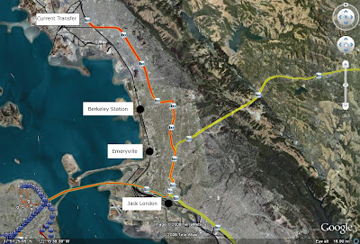
I think a more comprehensive metro system would be better to connect all the places but the MTC and others haven't been talking a lot about real core capacity increases like they should. The easiest would be to build a small loop track for Amtrak next to the West Oakland BART station. There's room and you could even use the aerial rights to pay for the small improvement and transfer station. This would pay off huge. West Oakland is the best connected station in the East Bay with more trains coming through than any other station. With the Amtrak Connection, you could get from Sacramento directly downtown without much waiting, considering the 2 minute headways into San Francisco at West Oakland in the mornings. Also, its a faster way to Oakland than from the Richmond Transfer, which is good if you're going to Berkeley. This would be a very cost effective option in my opinion to make Amtrak more attractive and might even create the need for even better service.

Thursday, July 24, 2008
And So It Begins...
Sound Transit 2.1 is on the ballot in Seattle. Where is the support badge? :) Check out STB for some liveblogging goodness. It looks like we're going to have a fun night in November when these votes take place. We'll be live-blogging results for LA, Seattle, and perhaps San Jose during the election. If there are more, we'll make sure to cover them.
Sunday, June 22, 2008
Arlington Did It Right
One of the things that bothers me these days is the need for the FTA to judge things based on cost and not long term benefit. An article in the Washington Post discusses the long term benefits that the planners in Arlington VA saw when they decided to run the Orange line underground and away from the freeway.
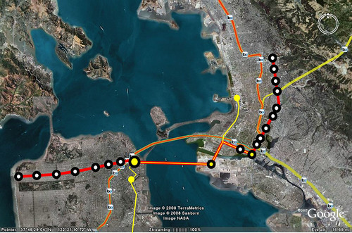
It got me thinking, what would BART look like if they had made the decision to build like Metro in DC and run the line through main corridors instead of down the center of the freeway. Here is what I came up with. The dotted lines and black dots I drew and the regular line and existing stations are shown by the little BART symbols.
If I were to speculate that these stations would have the ridership of 24th and 16th street mission, we would be seeing an additional 110,000 riders.
Since BART didn't learn anything from Arlington either, the BART to San Jose line will make the same mistakes, running on existing ROW instead of down the main corridors where its needed. The same exists with the BART to Livermore extension which we discussed earlier.
Monday, June 9, 2008
Assorted Bay Area News
Update: I changed the time of the Livermore meeting to 6pm as it was pointed out in the comments.
Whoa Muni. Looking at the ridership statistics on light rail from this last quarter, more people are definitely riding the rails. 173,000 a day is pretty good I would say. Although it sounds weirdly high. The Transit Effectiveness Project when taking ridership accounted for 157,424.
Also, if you're interested in the Livermore BART extension, there will be a public meeting Wednesday June 18th in Livermore at 6pm. I'm thinking I might show up, given that I'm on that side of the Bay on Wednesday evenings. Here's a post we wrote a while back on it.
More info:
Robert Livermore Community Center, Larkspur Room
4444 East Ave.
Livermore, CA 94550
The website to view the alignments is at www.barttolivermore.org
Their contact info is:
Phone: (510) 464-6151
E-mail: info@barttolivermore.org
H/T to Joel for the email.
Friday, April 11, 2008
Overheard in Oakland
A real conversation I overheard today:
Girl #1: Have you learned the bus routes yet?
Girl #2: No I have only used BART.
Guy #1: BART is much better than the bus
Girl #1: I use the 51 sometimes, it comes all the time, but I can't read on it.
Guy #1: I can't either, I feel like I have no room for my arms on the bus and it bounces all over the place
Girl #1: Yeah.
Girl #2: Well I'll figure it out.
Girl #1: Just take BART if you have a choice.
I seem to run into planning related conversations in the background wherever I go. The other night I was eating sushi with a friend and one lady in front of me loudly said: "Urban Planners don't know what they are doing, they just build those roads everywhere" and made a circular motion with her hand. I didn't say anything, but I was thinking "that's the highway engineers lady."
Tuesday, March 18, 2008
If You See Someone, Say Something
Ben has an post up about subway love in NYC. I've often wondered what, if any, etiquette there was to talking to girls (or guys) that caught your eye on transit. Some of my friends have said that it creeps them out while others are indifferent. One of my friends said that she gave a specifically creepy guy an evil look until he moved seats.
Apparently its not unusual to find creepy people on the subway, but its not unusual to see cute girls either...although most seem to have wedding rings. I certainly don't want to get the evil eye and I usually try to follow the golden rule, do unto others... And since I really don't like being bothered, I find it really hard to bother other people. So I end up listening to NPR or watching Diggnation and every once in a while catching a glimpse of a cute girl walking on or off the Muni or BART.
Apparently its not unusual to find creepy people on the subway, but its not unusual to see cute girls either...although most seem to have wedding rings. I certainly don't want to get the evil eye and I usually try to follow the golden rule, do unto others... And since I really don't like being bothered, I find it really hard to bother other people. So I end up listening to NPR or watching Diggnation and every once in a while catching a glimpse of a cute girl walking on or off the Muni or BART.
Sunday, January 13, 2008
Thinking Big: The Next Bay Area Project
I know that BART to San Jose is in the pipeline and as usual it wasn't planned to serve people but to be cost effective. This means that it goes where no one is along available ROW and skips major employment centers except Downtown San Jose. You would have thought that we might have learned something from the planning of BART in Oakland and Berkeley but apparently not.
But that isn't what i really wanted to talk about. I have a new idea for the Bay Area's newest New Start/Transit Project. I'd like to call it the Subway to the Sea 2, Urban Core Capacity Enhancement. The title is a nod to the Subway to the Sea bubbling up in LA and the New Jersey Access to the Core tunnel under the Hudson. If we're going to densify the bay area further, we need more of a metro system along major corridors. We need to be cost effective, so we should start with a corridor that would generate a lot of new ridership. So how about we build a line between the beach and downtown on Geary, build the new trans-bay tube that's been planned, and build up Broadway in Oakland to Rockridge and Berkeley under the 51 line.
Current ridership in this corridor is 56,000 for Geary and 18,600 boardings on the 51. This means that if everyone changed modes (which we know there still has to be a surface bus line for shorter trips) there could be about 80,000 riders. Given the speed of the new line and convenience it could increase ridership to way over 100,000 a day just on the line. This is a third of BART's ridership. Now the line is 19 miles from Berkeley to the Sea along the route I mentioned.
Now the line wouldn't just generate a lot of ridership, but it would generate a lot of new TOD, Office and Residential. In Oakland on Broadway, there would be a surge in new development along the corridor between College Avenue and Downtown. It's possible to capture a lot of the office and residential markets and take some pressure off of the outer sprawling suburbs. It will also take pressure off of the almost at capacity Transbay Tube.
Another feature of this would be the tunnel under the bay. it should be designed to be dual mode so that Caltrain/HSR could go to Oakland, Emeryville, and/or Jack London Square. That way Caltrain could extend into downtown and across the bay to Emeryville and possibly beyond making a connection between the jobs there and Silicon Valley (Yellow). It's possible to electrify the line all the way up to Martinez making commutes from around the horn easier with new stations in North Richmond and Hercules. It might also provide a way to keep trains away from Jack London which has had some issues with accidents. It would be a big project and more than likely cost a lot of money, but it will also be a huge ridership generator. Not only will you get over 100,000 from the subway alone, there will be the tens of thousands that want to get across the bay with a one seat ride to Emeryville and Jack London Square.
Tuesday, December 11, 2007
Transit & Acupuncture
So I've been kinda sick for the last few months with a number of things like vertigo and sinus infections. I've decided to go get acupuncture and see if it changes anything. So today was going to be my first day and I wanted to go to my Gramma's afterwards so i decided to drive. Well the transit gods were not happy about that so they smited my car mid bay bridge. I pulled off onto treasure island as my engine temperature light was flashing at me and checked the temperature. It was above normal but wasn't to the red yet. So I let it cool off for a little bit and started to drive again. I go to the other end of the bridge before I had to stop again. Eventually I got the car to the Volkswagen dealership in Oakland and took the 51 to work downtown.
So now I had to get to the acupuncturist in Montclaire. I left an hour before the appointment as the 59 comes every hour from Lake Merritt BART. I sat in the back of a 30 foot VanHool bus and watched the really nice houses pass by on the hills. It was actually a nice ride if not a little bumpy. But there was a catch. My appointment was going to be over at 5 but the last 59 went to the Rockridge BART at 4:15 or so. Not good. So I had to figure out a way back. Well where the 59 dropped off the 18 picked up and I was lucky enough that it ran every 15 minutes into the evening. So when I was done at 5 I hopped on the 18 and traveled on the other side of the hill from the 59. It took me to the 12th Street BART station and I hopped on the 24th street and mission turn around train to go home since I wouldn't be going to my Gramma's house.
I was thinking a bit negatively that there wasn't a 59 but my roommate pointed out that we are lucky to live in a fairly transit friendly place in the bay area and the fact that there was an 18 at all was good. It was still at 15 minute headways so yes, that was pretty good. I imagine that if I were in Houston or somewhere else this wouldn't have worked. So my car died, but i knew that I could depend on transit to get me where I needed to go. It took a little more time, but I got to watch the world go by instead of having to slog through traffic.
Wednesday, November 28, 2007
Transit Effectiveness Project
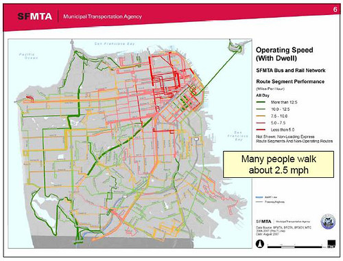
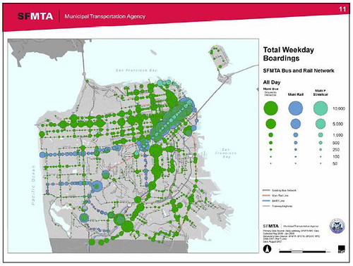
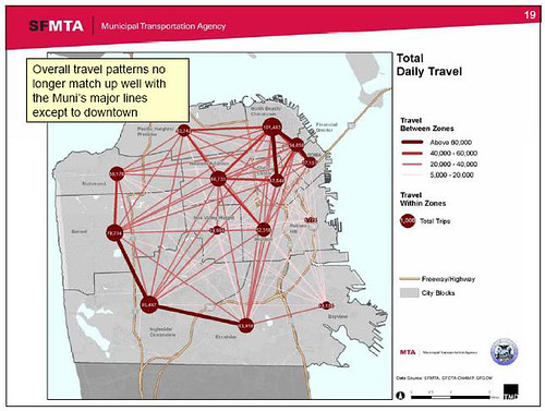
I went to a meeting tonight where there was a presentation on the transit effectiveness project in San Francisco. I wish I would have had my thumb drive as there were some fascinating maps with great data. I found them but they aren't high quality. Here is the link to the Geary data showing where people get on and off the bus. If only all transit agencies went and got this type of information, we would know a lot more about operations. The following maps are located in this presentation. All the screen shots below are courtesy of Muni.
Operating Speed: This shows where Muni is really slowed down by traffic. No Surprise that Van Ness and Stockton are some of the worst. I wish we would have had this data before the 3rd Street LRT project was started. Take a look at that street. Green. This is why data is important. It makes political decisions much easier. Now thats not to say that it won't get more congested as the are grows around light rail and it needed to become rail at some point, but there are many pressing needs in the city, mainly Van Ness and the long orange Geary.
Boardings: This shows where people board the buses. The most effective transit is on the main corridors and major traffic generators. It's interesting to note that where there is a high capacity spine, there are a lot of boardings. Most noticeable is along Mission BART. It shows how system boardings would probably improve if BART was expanded to Geary then down 19th such as proposed by SF Cityscape. It would improve boardings on the bus lines connecting to the stations.
Trips: The above observation is proven below in that there is a missing link between the Sunset and Richmond districts. The red dots are total trips between districts. Since there are a lot of trips North from the Richmond South towards SF State it would make a lot of sense to have rapid transit fed by east west buses.
Data. It's an amazing thing. According to one AC Transit board member at tonight's TALC meeting, they will be doing this soon as well which should bring some even more interesting results.
Sunday, November 25, 2007
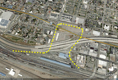
Livermore BART Extension
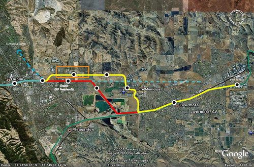
Driving home from Bakersfield today I was thinking about possible extensions to BART as I passed through Livermore. While I'm not sure expanding BART as a technology is a very smart idea because of expense, there are a few configurations where it might make sense. But might not. If you take a look at Pleasanton today, you'll notice that on the North side of Highway 580, there are some new very dense developments that might be well served by a good transit connection. You won't be able to see them on the aerial photo, but they are in the orange box below.
Planning for this extension has been on BART's mind for but studied seriously since at least 2003. The study initially looks at just going down the I-580 Median. Boooorrrrinnnggg and cheap. From the BART study done by Nelson Nygaard below...

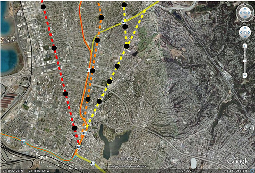
The study also looks at connections to Walnut Creek, but we're going to focus on the Pleasanton area extension. Also, BART is building an infill station at Dublin. It's represented below as a black and white dot. The blue line is the Dublin/Pleasanton BART line which goes to SFO. The green line is the ACE commuter rail that goes to the Central Valley. This was also the route for the Altamont high speed rail alignment I believe.
But here are possible alignments. The yellow line is my favorite. It goes through the dense neighborhood being created to the north (orange box) and moves along vacant land that could be zoned for dense office and residential. It also passes the Livermore Airport, downtown livermore and gets right next to the Livermore National Labs facility which the north side of the station area could provide park and ride facilities for those driving over the Altamont who didn't use the ACE Train.
The red line uses the freeway until it gets to a crossover point. The cross over point allows the transit to move onto the ACE ROW and stop at stations up there. It along with the freeway median all the way out to Livermore plan are the cheap ways out. They might be cost effective but they do not provide opportunity for livable neighborhoods around the stations, since there is are 4 lanes of the freeway running on each side of the train. This will make the stations fairly auto/park n ride oriented. Also, if
Any thoughts? (The right side is cut off. Click on the picture to get a full view)
Planning for this extension has been on BART's mind for but studied seriously since at least 2003. The study initially looks at just going down the I-580 Median. Boooorrrrinnnggg and cheap. From the BART study done by Nelson Nygaard below...

The study also looks at connections to Walnut Creek, but we're going to focus on the Pleasanton area extension. Also, BART is building an infill station at Dublin. It's represented below as a black and white dot. The blue line is the Dublin/Pleasanton BART line which goes to SFO. The green line is the ACE commuter rail that goes to the Central Valley. This was also the route for the Altamont high speed rail alignment I believe.
But here are possible alignments. The yellow line is my favorite. It goes through the dense neighborhood being created to the north (orange box) and moves along vacant land that could be zoned for dense office and residential. It also passes the Livermore Airport, downtown livermore and gets right next to the Livermore National Labs facility which the north side of the station area could provide park and ride facilities for those driving over the Altamont who didn't use the ACE Train.
The red line uses the freeway until it gets to a crossover point. The cross over point allows the transit to move onto the ACE ROW and stop at stations up there. It along with the freeway median all the way out to Livermore plan are the cheap ways out. They might be cost effective but they do not provide opportunity for livable neighborhoods around the stations, since there is are 4 lanes of the freeway running on each side of the train. This will make the stations fairly auto/park n ride oriented. Also, if
Any thoughts? (The right side is cut off. Click on the picture to get a full view)
Wednesday, September 19, 2007
We Need Subways, But How Will We Pay For Them?
Los Angeles
Now here's an idea, lets pay for transit lines like we used to, tie them to real estate. Obviously this isn't a way to pay for the whole line (unless zoning was lifted and there was a development free for all) but it should be considered for partial funding. It's possible that a development fund could be put together to fund stations, or private developers could bid to build high rises with the stations. I'm sure there are a lot of other innovative ways to create a TIF district. Maybe there could be a roof tax for every new unit along the line. Anyone have any innovative ideas for funding transit?
San Francisco
Speaking of subway dreams, Polk Street Blog reminds everyone that there will be a BRT planning session for Van Ness in San Francisco. I'm kind of upset that I'm going to miss it because I would have gone and raised some issues with the BRT scheme. This is one of the lines that I think should be a Subway and for two reasons(they both might fit into the same reason):
A. Van Ness is the main through street to get from 101 South to the Golden Gate Bridge. The street is already crowded and on many days traffic does not move an inch. I'm not asking for a freeway because that would be a dumb idea (one that almost happened). But taking away two lanes on the busiest North-South street in town for buses that will still get caught in cross traffic every block? Could ITS realistically keep up with that? There are 31 crossings from Fort Mason and Market street which is only 2 miles.
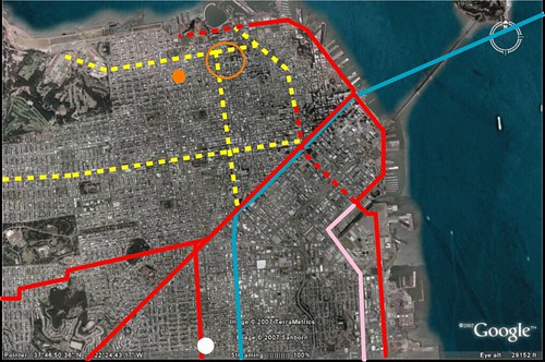
B. I want to get to the other side of the city in less than 45 minutes and I don't think that is possible on the surface streets. By other side of the city I mean 3 miles between my house(white dot) and the bar where I watch UT play football(Orange Dot) and my friends Mark and Ade live(Orange Circle). It's like I have to plan a day just to see them without driving my car. Taking the J to the 47/49 is a fun bumpy people watching experience, but I imagine I could cut this trip to 25 minutes with a subway which would make it about the same convenience as my car (more so because I don't have to park).
So zone up Van Ness and do it with TIF districts. Make the Van Ness/Geary/Subway to the Sea a state TIF project to see if it works. If it doesn't work as well as it should, well these are good projects that should be funded anyways, if it does work, it can act as a model for cities around the country who might want to build a subway line or extension.
I've made this map before but just so people can see what I'm talking about check out the map below. The blue line is BART, the Red lines are existing MUNI Metro lines. The red dashed lines are planned rail extensions and the yellow dashed lines are subway projects I wish would happen so I can eat dim sum on Geary or watch the UT games on Union without spending 2 hours on the bus and J.
Ridership on the largest bus lines in SF is in this article.
Now here's an idea, lets pay for transit lines like we used to, tie them to real estate. Obviously this isn't a way to pay for the whole line (unless zoning was lifted and there was a development free for all) but it should be considered for partial funding. It's possible that a development fund could be put together to fund stations, or private developers could bid to build high rises with the stations. I'm sure there are a lot of other innovative ways to create a TIF district. Maybe there could be a roof tax for every new unit along the line. Anyone have any innovative ideas for funding transit?
San Francisco
Speaking of subway dreams, Polk Street Blog reminds everyone that there will be a BRT planning session for Van Ness in San Francisco. I'm kind of upset that I'm going to miss it because I would have gone and raised some issues with the BRT scheme. This is one of the lines that I think should be a Subway and for two reasons(they both might fit into the same reason):
A. Van Ness is the main through street to get from 101 South to the Golden Gate Bridge. The street is already crowded and on many days traffic does not move an inch. I'm not asking for a freeway because that would be a dumb idea (one that almost happened). But taking away two lanes on the busiest North-South street in town for buses that will still get caught in cross traffic every block? Could ITS realistically keep up with that? There are 31 crossings from Fort Mason and Market street which is only 2 miles.
B. I want to get to the other side of the city in less than 45 minutes and I don't think that is possible on the surface streets. By other side of the city I mean 3 miles between my house(white dot) and the bar where I watch UT play football(Orange Dot) and my friends Mark and Ade live(Orange Circle). It's like I have to plan a day just to see them without driving my car. Taking the J to the 47/49 is a fun bumpy people watching experience, but I imagine I could cut this trip to 25 minutes with a subway which would make it about the same convenience as my car (more so because I don't have to park).
So zone up Van Ness and do it with TIF districts. Make the Van Ness/Geary/Subway to the Sea a state TIF project to see if it works. If it doesn't work as well as it should, well these are good projects that should be funded anyways, if it does work, it can act as a model for cities around the country who might want to build a subway line or extension.
I've made this map before but just so people can see what I'm talking about check out the map below. The blue line is BART, the Red lines are existing MUNI Metro lines. The red dashed lines are planned rail extensions and the yellow dashed lines are subway projects I wish would happen so I can eat dim sum on Geary or watch the UT games on Union without spending 2 hours on the bus and J.
Ridership on the largest bus lines in SF is in this article.
Sunday, July 8, 2007
Autocentricity in Consumerism
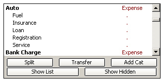
An odd thing happened to me today. I installed Quicken and downloaded my bank data onto my new computer since my hard drive crashed a few months ago. As I was categorizing each purchase, i came to a point where I couldn't find a category to put one of the recurring purchases I was making, BART tickets. There was no section for transportation costs because it was only car costs. There are so many things that go into auto costs including the list below. One thing that I had to add to this is traffic and parking tickets, of which I have gotten a few.
But what does this say about the overall consumer culture and our debt? Given that the median balance on the American credit card is $1,900, and 43% of Americans spend more than they earn, does this mean we are slaves to our cars?
According to this MSN Money article, the debt of America outside of our Mortgage is largely tied to non-revolving loans like the ones available for people to buy cars. That's just the capital cost for the car. Now what about operating the thing and roads? In 2005, the average American spends 18% of their income on transportation. Recent research suggests that this fluctuates between the exurbs and transit rich urban core with a difference of up to 16% between the extremes of 25% and 9% respectively.
In my own experience, I drive my car once a week and fill up the tank once a month. I probably wouldn't drive at all if my grandmother didn't live so far from BART. Otherwise I take Muni, BART, or walk. I would say that I'm around the 9% in transportation costs which allows me to pay a bit more in rent than I normally would be able to afford. But I'm also able to save up some money.
So in a consumer based, auto oriented society, we are largely tied to our cars, figuratively and sometimes literally. Over the last 60 years we've been so tied down that even personal finance software doesn't give us a transit choice but to enter it in ourselves. But as we've found out from parking, when given the choice for someone to unbundle, a lot of people will choose the alternative because there is one to choose. Someone gave an analogy recently, and forgive me for stealing it if you're reading but if there is a shelf full of only Pepsi how can you say that no one wanted to buy Coke? The choice wasn't there.
Thursday, June 28, 2007
BART in 50 Years
Recently there has been a lot of news about the next 50 years at BART. Many projects are discussed but it's interesting to note some of the big ones such as a new transbay tube. The new tube hopefully would carry commuter rail as well as BART trains. It might also be worth noting that this past year carried BART's highest ridership ever. Below is a really fascinating iteration of a regional rail plan at SF Cityscape. I really like how it goes up Geary and South on 19th Avenue towards the Daly City Station. That would be huge for riders in the Sunset and Richmond districts trying to get to downtown San Francisco. But the question is, should it be Muni or BART? Also, a line through Emeryville would be awesome too. I wouldn't mind living there if there were more transit options.

Subscribe to:
Posts (Atom)