Showing posts with label Corridor. Show all posts

Monday, August 10, 2015

Map Wire: Calculating Underutilized Land on Transit Lines

For Realizing the Potential: Expanding Housing Opportunities Near Transit, a report done for FTA and HUD, we looked at five transit lines that were existing or under construction at the time. The lines included different transit modes including streetcar, light rail, and commuter rail. 

This map shows the method we created to look at underutilized land, or land where the building values were worth less than the land on which they were located.  Parcel data is always tricky given different estimating methodologies and tax systems as well as values attached to different land use types, but using this ratio gives an idea of how much land along a line might be available for redevelopment.

In the maps you can see that an established line such as Boston's Fairmount has less underutilized parcels than say Charlotte.  The parcels are also much smaller.  But Charlotte, based on the maps posted last week, has a lot of industrial land.  There's also something to be said for industrial preservation, and transit lines can create a lot of pressure for redevelopment, even in places with productive industrial uses.  It's a less mentioned form of displacement that has been happening in cities with industrial cores that have been on the receiving end of a lot of redevelopment and adaptive reuse. 

In any event, this map might be of interest. 


Tuesday, January 25, 2011

Unconventional Thinking On Charlotte

A lot of times I'll see an article or a piece that I want to comment on but hold off to see if more of a complete picture comes through. I'm glad I did this time because I've waffled back and forth on the idea of Light Rail on Charlotte's Independence Boulevard. When the debate raged between BRT and LRT on this corridor back in 2005-2006 I felt like BRT would have given the corridor a raw deal. Partly because frequencies and vehicle capacity would mean much more in operating costs even if the capital costs were lower.

At that point there was a lot of support from local mayors (like former Matthews Mayor Lee Myers) and communities for the light rail line but as usual no money. So the decision to pick a locally preferred alternative was shelved for a later date several years down the road when there might be money available.

However recently Mary Newsom at the Charlotte Observer tweeted then blogged about a ULI session that suggested that Independence should be HOV lanes and a Streetcar should be run up Monroe Road. Yonah has a good graphic for this over on the Transport Politic. Initially when I saw the tweet I thought that was a really dumb idea. I had seen the fight between LRT and BRT before and the current suggestions were for the line to be a rapid bus line in the HOV lane and a streetcar on Monroe Road.

While still rapid transit, all that type of transit would do is reward people living further and further away from the city without changing any of the land use patterns closer to the city center. The streetcar might do it but I'm starting to wonder whether line haul streetcars are a great idea for places that would rather have more rapid transit options. Just as Yonah points out, you aren't really going to be getting anywhere fast.

But then I started to warm up to the idea of HOV lanes considering that freeway alignments don't really work well for TOD considering most of the really good property is taken up by the size of the road. Especially if the road is going to be the size of a freeway at some point ceasing to be an actual boulevard. But that is the rub.

The problem here is the same problem that's happening when TTI releases its urban mobility report based on a travel time index. All the engineers at the state DOT care about at this moment are making the trip from a place outside of the Loop into downtown faster. They want to widen this road and make it a full fledged freeway. But that decision alone goes against the centers and corridors plan that Charlotte developed after they voted for the half cent sales tax initially and revamped in 2010.


The TTI travel time index is the wrong measure, especially if it is going to push infrastructure investment that drives the vicious cycle of speed to further away parts of the region. We know now rather that access is a more important measure. CEO's for Cities laid it out in their Driven Apart study, showing that travel time skews the data towards travel flow rather than closer access to work or other destinations.

What this means for Independence Boulevard is that if the NCDOT gets a hold of it and upgrades the outer sections to a grade separated highway, then the ability to change those patterns for better access to an employment node is lost forever. One of the commenters on Yonah's post noted that the outermost piece of Independence is actually a boulevard instead of a highway. Not a boulevard in the sense of a grand boulevard but it is still not a grade separated highway.

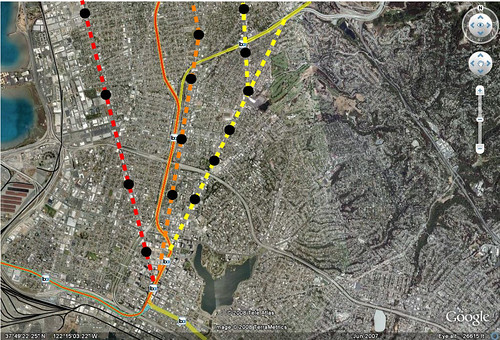
The one problem with changing it to a grand boulevard is that urban development patterns that people like are harder to realize further from the downtown or major employment cores. Because of land values and other market forces, the further you get out from major gravity centers like downtown Charlotte or the University, the harder it gets to realize new urban style development. In fact, the South Corridor already shows that development further out is harder to realize. The map below shows development projects from 2007 and before on the South Corridor. The basic distance from downtown before development starts to wane is approximately 3.5 miles. Basically, the strong market of downtown seems to be extended with access provided by the transit line. This is about a 13-15 minute trip to downtown.

Source: Realizing the Potential One Year Later

Part of the reason for this is the travel time people are willing to endure to get downtown. It's not likely that people will take the streetcar from the outer edges of Monroe Road or Central Avenue unless they have no other options. Additionally, this is why an Independence Light Rail line gets a bit tricky. But we need to start thinking of Independence not as a corridor feeding downtown but rather as a future mass that will have its own gravity. And I believe that gravity can be achieved with a strategic investment in the road to make it an urbanism changing Boulevard.

Considering the section of Independence that is already most like a freeway is within the 3.5 mile radius, its hard to imagine much happening in the short term along the Boulevard. Below shows the ~3.5 mile radius. The yellow shows the part most like a freeway already. The red shows the Boulevard and the light blue is the railroad corridor that is parallel to Independence. The Orange is the Central Streetcar.


This means that a Monroe Streetcar would be good for the inner 3.5 miles but two different service types will be needed further out for shorter and longer types of trips. This also leaves an opportunity for a Grand Boulevard that can attract business and development over time if the road is done right and parcels are slowly transformed into gridded and walkable areas. The approximately 120 feet of right of way are more than enough to build a road that would be friendly to transit, bikes, pedestrians as well as autos.


This corridor specifically could pull offices out to 7.5 miles, creating a new employment corridor which could bring land values up and with it densities over time. Creating a new center should be the goal, not making it another pass through on the way to downtown with HOV lanes for buses that are going to get 5000 riders a day at best. Additionally, by creating two centers with a rapid transit line and streetcar between, the market between the two centers gets stronger, allowing it to support the types of urban development people always draw on their maps at public meetings.

Photo via Hugeasscity

I realize this might be a bit too forward thinking for some people but ultimately we have to change our mindset about what is possible in urban places if we are to give people opportunities to choose different housing and mobility types. Yes this corridor is going to be auto dominated for the near future but that doesn't mean we have to doom it to freewaydom and forever feed sprawling development patterns further and further out. In fact, it's possible to create a new center that attracts new transit trips from within its own gravitational field.

Monday, February 16, 2009

Build In California Alone

So says Ed Glaeser. He states that because of the temperate climate, more people should live in density in California cities to increase environmental savings. Though this doesn't really work if the people moving here don't have water, the climate changes, and we can't grow food in the central valley.

If this is along the same lines as Randal O'Toole and Wendel Cox are pushing, build in the preserved open spaces at existing densities with limited regulation, then no thank you. However, if its building more density in greyfields and on transit corridors with better transit then sure. But people shouldn't mix the two, that would be a disaster.

Wednesday, December 3, 2008

Pent Up Demand, Synergy, & The Market

Chris Leinberger is hopping on the urban train so to speak. Brad Plummer's post over at TNR's The Vine has already gotten some coverage at Greater Greater Washington and The Bellows but here's the money quote that discusses the lacking supply of walkable communities people want but can't afford.
By his count, some 30 to 50 percent of residents in U.S. metropolitan areas want to live in a walkable urban environment—a trend fueled by the growing number of single and childless couples, who will constitute 88 percent of household growth through 2040. Trouble is, he estimates there are currently only enough walkable neighborhoods to satisfy about 5 to 10 percent of metro residents, which is why rents in transit-accessible areas are so exorbitant.
The other side of this as both blog posts noted above is the issue of land use and zoning. I'm going to throw another wrench in and say there has to be a market. There have been a few rail projects that hope the build it and they will come system will work but there needs to be a concerted effort and existing market to make it work precisely because of the problems with our zoning code. An example of this is Cascade Station in Portland. On the way to the airport, the Bechtel company traded building the line for the land at the station. Unfortunately 911 hit a few days close to the opening of the line and the market dropped out from under the developers.

There's also the synergy issue. Places like the Pearl District and the South End in Charlotte were the next places to grow and close to the downtown urban market. I would say the transit was able to shape the development intensity. Further down the South Corridor has been a bit slower to take off. Over time as the prime properties are expanded, I expect the development to move further south along the line.

So while I see there is demand for walkable urbanism as Chris calls it, there are timelines of implementation that should be mentioned as well so that people don't expect overnight change. The Rosslyn Ballston corridor didn't take off over night either. I feel like the synergy point is an important one that gets missed from time to time when people expect TOD everywhere once the line opens. It's a long term investment with long term results. It will be interesting to see what happens in Denver as the opening of the whole transit system almost at once under the Fastracks program. I have heard some state that the push and focus that happened along the Southeast Corridor won't be replicated because the demand will be spread out among all the opening stations. It makes for an interesting test of the synergy idea and whether transit will be able to focus the intensity as it has in other corridors that had all the attention.

On the issue of paying for lines, I think developers will get a major boost from the infrastructure investment and should pitch in, or at least not be able to keep the massive windfalls from the investment that was made by everyone. But its also dependent more on vacant and extremely underutilized property appreciation. More money will be generated through vacant to build out than the appreciation of properties that already exist. Too many people think value capture will always be the answer when sometimes it will not, because the increment is too small to generate the funding needed. These issues and a ton more are discussed in a recent paper on Value Capture by the Center for TOD. We'll discuss that piece another time.

Also, a while ago I covered some key quotes in Chris Leinberger's book, The Option of Urbanism. Here's the series post by post.

Series Intro
The Favored Quarter
The Endless Landscape
Real Development Subsidization
Metro Brings Change
Subsidizing the Rich

Sunday, June 22, 2008

Arlington Did It Right

One of the things that bothers me these days is the need for the FTA to judge things based on cost and not long term benefit. An article in the Washington Post discusses the long term benefits that the planners in Arlington VA saw when they decided to run the Orange line underground and away from the freeway.

It got me thinking, what would BART look like if they had made the decision to build like Metro in DC and run the line through main corridors instead of down the center of the freeway. Here is what I came up with. The dotted lines and black dots I drew and the regular line and existing stations are shown by the little BART symbols.

If I were to speculate that these stations would have the ridership of 24th and 16th street mission, we would be seeing an additional 110,000 riders.

Re-Imagining-Broadway

Since BART didn't learn anything from Arlington either, the BART to San Jose line will make the same mistakes, running on existing ROW instead of down the main corridors where its needed. The same exists with the BART to Livermore extension which we discussed earlier.

Saturday, June 21, 2008

Transportation Corridors

This is what you get when you have a long term plan for developing a corridor and do it right. I was watching some baseball today and the game was in Boston. They showed an aerial photo of the Back Bay and it got me thinking...corridors.

Arlington County Virginia


Wilshire Blvd: Flickr by ATIS 547


Boston Back Bay on the Green Line


Peachtree Street in Atlanta


I know there are more. Anyone have a corridor to share?