Showing posts with label Transit Networks. Show all posts

Thursday, February 21, 2008

Is Auto Ownership Tied to a Reduced Savings Rate?

We know that cars cost a lot of money. Aside from the up front capital cost, operations cost people at least $8,000 per year. But ever since cars were produced for the working man by Henry Ford, it looks as if the purchase and ownership of these vehicles has cut into American wealth accumulation. If you look at the savings rate over the last century, it seems to be an inverse relation to auto ownership. This chart created by Scott Bernstein at the Center for Neighborhood Technology shows this relationship. (I've seen this chart in a number of iterations but this is all I could find online)

While everyone thinks that America is a wealthy nation, many people spend a good portion of their money on transportation. But it doesn't have to be this way. Cities that have good transit networks allow people to save money and cut overall emissions.

I want to reiterate that I think cars are an important part of our transportation network, but I think our complete dependence on them in most of the United States will lead many to the poorhouse sooner rather than later. In order to stem the tide, we need good transit. It allows people to pool their resources to pay for transport and allow for the building of wealth.

Saturday, February 16, 2008

Increasing Job Densities an Appropriate TOD Strategy

It might seem like a duh moment, but Prof. Gary Barnes paper discusses in a paper he wrote for the Journal of Public Transportation that it's not just residential density that determines transit usage, but rather where people are going.

Using regression analysis, he showed that in Minneapolis, aside from developing residential densities, transit share can be increased by building up commercial centers. In the regression, he showed that for every 1000 people per square mile that the residential density grew, the increase in transit's share to downtown increased 2.4% versus .6% increase when people went to suburban jobs. The same thing happened for increases in low income users. For every 1% increase in low income population per square mile, increases were noted. The chart that shows the results is below.


He also relates the concentration of regional jobs in major centers directly to how much transit people take. An example from the article is below.


There are a few caveats including the need for quality transit and parking regulations in these centers that encourage transit ridership. But just having a center of commerce isn't good enough. Places that have a lot of jobs like Pleasanton need to be better organized and less suburban office park.

Recently however, many people have been focused really heavily on residential densities, which are important, but I haven't seen many programs that create a regional job placement and growth strategy. This could be part of the key for increasing transit's use for work trips.

I have a feeling as well that pushing for dense commercial centers with mixes of retail and office then connecting them with high capacity transit will go a long way towards increasing transit's ability to cut congestion in the peak hours. It might also be a self-fulfilling prophecy of sorts, creating a cycle of more transit and more office development in the cores of a region.

I know that this is kind of a 'duh' post. But having numbers to quantify the effects of connecting residential areas to large employment centers is really important in moving forward with policies that promote transit ridership. Thanks Prof Barnes for this paper and for your conclusion:

Planners and policymakers hoping to manage urban traffic congestion through increased transit use are limited in the short term by the strong influence that existing land use exerts on mode choice. While this point has been widely acknowledged, most research and policy discussion on this topic has focused on increasing residential densities. However, the conclusion of this article is that the development and expansion of very large, high-density job centers is the best tool available for most cities to achieve substantial increases in transit use.

While there are many ways to improve transit use, achieving the substantial increases necessary to impact congestion levels will probably ultimately require greatly improved service frequency or higher costs of driving, such as parking charges. Higher parking charges will be politically infeasible in the absence of adequate transit service as an alternative; however, improved transit service is hard to justify in the absence of a sufficiently large market.

Creating a large market appears to reduce to two options: the well-known solution of increasing residential density and the less-considered option of focusing on the work end of the trip. While both of these tactics appear to be effective in principle as well as practice, it is, for a variety of reasons discussed in this article, very difficult to have impacts on residential density that are large enough to have regional significance.

The constraints that limit the use of residential density increases as a tool are not in force to nearly the same extent for commercial development. A gradual transition of a relatively small amount of office space from isolated or low-density settings into a few large dense centers could lead to sizable increases in regional transit use in a relatively short time.

The Twin Cities area illustrates the possibilities of this approach. There are two downtowns, but Minneapolis is much larger and is geographically in the center of the developed area. Downtown St. Paul is relatively small and close to the edge by comparison, yet still attracts a substantial transit share. This hints at the possibility that even suburban locations, if they are developed to a sufficient size and density, can become major transit attractors.

Increased densities at the work end of the trip, by making improved transit service frequency more viable, could also help to increase nonauto access to retail and other nonwork opportunities. While higher density residential development can also have an impact, the effect is much larger when the increased density occurs in or around high-density commercial areas, both because more trips will be made to these high-transit attractors and because these areas support relatively good transit service going out as well as coming in. Increased commercial densities, especially in the suburbs, may be the only tool available for inducing significant transit use from the vast suburban areas of most cities that are already developed at low densities, and which will probably stay that way forever.

Monday, January 28, 2008

Electric Transit Paragraphs Back in Report

As was reported last week, Paul Weyrich was really mad that his paragraphs on the importance of electric transit were taken out of the National Surface Transportation Report. Well this week Renew America reports that it was a misunderstanding and they will be put back in.

Both Weyrich and Commission Vice Chairman Jack Schenendorf — in discussions with us — agreed that a dispute (again see last week's column) over a last-minute deletion of a pro-rail transit section of the commission study was a "misunderstanding."

There seemed to be agreement among the majority commissioners, including Steve Heminger of San Francisco — whose role in the controversy was discussed also here last week — that the situation "wasn't handled right," and that the deletion "should not have been made." The Bay Area Metropolitan Commission executive director has now signed off on a revised draft of the deleted section which was crafted — with Weyrich's approval — primarily by Commissioner Frank McArdle, a contractor from New York. (Bear in mind, again, we are referring here to discussions among the pro-rail majority. Peters and Co. are out of this particular loop.) The wording changed in some emphases, but in the end still stipulated that "Public transportation, especially in the form of electric railways, must and will play a significantly larger role in Americans' mobility over the next 50 years and beyond."
He also went on to say that he wouldn't be voting for John McCain, in part because of his role in trying to kill Amtrak.

Weyrich knows that Senator McCain, throughout his career, has been very anti-rail, and in that respect "would be [even] worse than the present [Bush] administration," whose Transportation Secretary Mary Peters (a big highway booster) has fought tooth and nail (as commission chairman) to block the pro-rail efforts of Weyrich and others allied with his 9-to-3 commission majority.
...

The Arizonan has said shutting down Amtrak — he's if elected — would be "a non-negotiable issue" for him. Short-sighted, indeed.
I'm guessing thats a deal breaker.

Friday, January 25, 2008

Calculating the Taxpayer's Real Expense

There is a discussion going on over at the Capricious Commuter about transportation funding resources. It was mentioned in a comment on a previous entry that 63% of the area's resources are going to transit when it only carries a limited amount of trips. But CC sets us straight by trying to calculate how much we spend all together on transit versus cars, not even counting all the parking garages.

So if we consider that, in 2005, the most recent year for which I have stats at arm’s length, Bay Area motorists drove nearly 58 billion miles, at AAA’s average U.S. operating cost of 52 cents a mile, that’s $30.2 billion to add to our transportation funding formula, and that still doesn’t include the purchase price of new cars.

That’s like a once-in-a-generation statewide transportation bond measure, but just for the Bay Area. We all, collectively and for the most part unwittingly, agreed to approve and finance that funding package.

So here’s the new math: $3 billion a year for transit, including fares paid by individual commuters, and $31.9 billion a year for the streets, roads and vehicles that operate upon them. That would be 8.5 percent of the Bay Area’s transportation spending.

My favorite comment, "We all, collectively and for the most part unwittingly, agreed to approve and finance that funding package." We only seem to complain when gas prices get a little higher.

Tuesday, January 15, 2008

Mary Peters Says...

Taking a look through the recent National Surface Transportation Policy Report, you can see what we are fighting in Washington when it comes to efficient electric transit. Mary Peters, Bush's Secretary of Transportation, (who said bikes aren't transportation on PBS) who was on the committee was on the dissenting side pushing the need to raise money from private companies through tolling and the usual Bush administration stances. But here is what stood out. Apparently, the opposition, including Mary Peters, say this about rail...

Some of the transit investments are not based on a strict benefit-cost analysis. The estimates for rail passenger investment needs ($7 - $9 billion per year, of which over $6 billion would be Federal grants) are similarly unrealistic. It is not clear that even our current investments in passenger rail yield benefits in excess of their costs; it is highly unlikely that $9 billion per year in cost-beneficial investment opportunities in passenger rail could be found.
She's right about one thing. Most transit investments aren't based on a benefit-cost analysis, today they are based on the Cost Effectiveness measure which does not measure many benefits of transit including economic development even though they have been asked many times by Congress to do so. It's funny that they don't ask any roads to go through such rigor. Is there a cost effectiveness measure for roads? No.

Unrealistic? I have a whole list of valuable projects here that could use funding. This shows how reality is lost on the current administration in terms of transportation investments and importance. I know that many of you would love to be able to compete for $6 Billion a year versus the current $1.6 B. Much of that money goes to larger cities as well such as New York (which i think should keep getting funding), but the new starts pipeline is said to be 50 years long. You can't tell me that the FTA couldn't use more funding for projects. In fact that is what people around the country have been asking for!

And in sure Bushy fashion, here is what they would do in writing if they had control (wait, right now they do). All highways all the time.

As is evident from the preceding observations, we would advocate a substantially different approach than that proposed by the Commission Report. Our approach would sustain current gasoline and diesel tax levels and refocus Federal efforts on

(a) maintaining the Interstate Highway System;
(b) alleviating freight-related bottlenecks that impede the flow of commerce and goods; and
(c) providing States with appropriate analysis, incentives, and flexibility regarding the adoption
of market-based reforms to their highway systems.
Tomorrow I'll talk about the majority recommendations in the report.

Sunday, January 13, 2008

Thinking Big: The Next Bay Area Project

I know that BART to San Jose is in the pipeline and as usual it wasn't planned to serve people but to be cost effective. This means that it goes where no one is along available ROW and skips major employment centers except Downtown San Jose. You would have thought that we might have learned something from the planning of BART in Oakland and Berkeley but apparently not.

But that isn't what i really wanted to talk about. I have a new idea for the Bay Area's newest New Start/Transit Project. I'd like to call it the Subway to the Sea 2, Urban Core Capacity Enhancement. The title is a nod to the Subway to the Sea bubbling up in LA and the New Jersey Access to the Core tunnel under the Hudson. If we're going to densify the bay area further, we need more of a metro system along major corridors. We need to be cost effective, so we should start with a corridor that would generate a lot of new ridership. So how about we build a line between the beach and downtown on Geary, build the new trans-bay tube that's been planned, and build up Broadway in Oakland to Rockridge and Berkeley under the 51 line.

Current ridership in this corridor is 56,000 for Geary and 18,600 boardings on the 51. This means that if everyone changed modes (which we know there still has to be a surface bus line for shorter trips) there could be about 80,000 riders. Given the speed of the new line and convenience it could increase ridership to way over 100,000 a day just on the line. This is a third of BART's ridership. Now the line is 19 miles from Berkeley to the Sea along the route I mentioned.

Now the line wouldn't just generate a lot of ridership, but it would generate a lot of new TOD, Office and Residential. In Oakland on Broadway, there would be a surge in new development along the corridor between College Avenue and Downtown. It's possible to capture a lot of the office and residential markets and take some pressure off of the outer sprawling suburbs. It will also take pressure off of the almost at capacity Transbay Tube.

Another feature of this would be the tunnel under the bay. it should be designed to be dual mode so that Caltrain/HSR could go to Oakland, Emeryville, and/or Jack London Square. That way Caltrain could extend into downtown and across the bay to Emeryville and possibly beyond making a connection between the jobs there and Silicon Valley (Yellow). It's possible to electrify the line all the way up to Martinez making commutes from around the horn easier with new stations in North Richmond and Hercules. It might also provide a way to keep trains away from Jack London which has had some issues with accidents. It would be a big project and more than likely cost a lot of money, but it will also be a huge ridership generator. Not only will you get over 100,000 from the subway alone, there will be the tens of thousands that want to get across the bay with a one seat ride to Emeryville and Jack London Square.

Subway-To-Sea-Access

Friday, January 11, 2008

Thinking Big in Raleigh-Durham

After a failed attempt at a regional rail system connecting Raleigh and Durham, the Triangle region has gone back to the drawing board and come up with 16 corridors that need transit. The local paper backs the idea because of success in Charlotte with their transit expansion which includes not only light rail, but express buses and increased local service. Recommendations will be coming soon on technology so we'll see what happens, but it sounds ambitious. According to the News and Observer.

The Triangle can afford to expand bus service and build new rail projects if local leaders make a "Charlotte level of effort," the head of a regional transit agency said Friday.

A new half-cent local sales tax could augment local and state transit funds to pay for 150 new buses in the next few years and launch more than $1 billion worth of capital projects by 2020, said David King, general manager of the Triangle Transit Authority.

Thursday, January 10, 2008

Seattle Streetcar Network

Diamajin at the Seattle Transit Blog has a post with a lot of comments (Please read them too) on an idea for a Seattle Streetcar Network. Check it out.

Thursday, December 27, 2007

Hampton Roads News

After Norfolk got a Full Funding Grant Agreement, Virginia Beach decides that they need to jump on the Light Rail bandwagon. From the Virginian Pilot.

Virginia Beach wants a $15 million grant from the Virginia Department of Transportation to help pay for the rail line that runs between Newtown and Birdneck roads if an agreement to sell it is ever reached.

The track is owned by Norfolk Southern Corp. and is considered the logical extension of Norfolk’s light rail project, which began construction this month with utility work at Harbor Park.

Monday, December 24, 2007

Further Expansion Considered in NC

Local Officials in Concord North Carolina are discussing whether to put a half cent sales tax on the ballot in order to Extend the North Corridor Light Rail line their way. This would bring rail by Loew's Motor Speedway and the NASCAR hall of fame into the next county.

Thursday, December 20, 2007

Metro Dreams

Earlier this month I posted on my dreams for San Francisco and East Bay Metros. Eric over at Transbay Blog has done the same. Check them out.

Sunday, December 16, 2007

Moving from Colors to Numbers

I've been noticing as part of the space race that most cities operate their rail lines in a color system, meaning each line has a color. A good national goal should be to get cities off of the color system and to numbers and letters like New York City. Why? Because if you have numbers and letters that means you probably have more options. There are a limited amount of colors to use for light rail lines. ROY G BIV comes to mind but of course there are others in between. In Austin you could have a burnt orange line. However if you have a color system, it most likely means there aren't a lot of choices of places to go in the city. If lines are as prolific as most bus systems, I think we'll start to see good things happen. What do you all think? Is this a good goal?

Tuesday, December 11, 2007

Transit & Acupuncture

So I've been kinda sick for the last few months with a number of things like vertigo and sinus infections. I've decided to go get acupuncture and see if it changes anything. So today was going to be my first day and I wanted to go to my Gramma's afterwards so i decided to drive. Well the transit gods were not happy about that so they smited my car mid bay bridge. I pulled off onto treasure island as my engine temperature light was flashing at me and checked the temperature. It was above normal but wasn't to the red yet. So I let it cool off for a little bit and started to drive again. I go to the other end of the bridge before I had to stop again. Eventually I got the car to the Volkswagen dealership in Oakland and took the 51 to work downtown.

So now I had to get to the acupuncturist in Montclaire. I left an hour before the appointment as the 59 comes every hour from Lake Merritt BART. I sat in the back of a 30 foot VanHool bus and watched the really nice houses pass by on the hills. It was actually a nice ride if not a little bumpy. But there was a catch. My appointment was going to be over at 5 but the last 59 went to the Rockridge BART at 4:15 or so. Not good. So I had to figure out a way back. Well where the 59 dropped off the 18 picked up and I was lucky enough that it ran every 15 minutes into the evening. So when I was done at 5 I hopped on the 18 and traveled on the other side of the hill from the 59. It took me to the 12th Street BART station and I hopped on the 24th street and mission turn around train to go home since I wouldn't be going to my Gramma's house.

I was thinking a bit negatively that there wasn't a 59 but my roommate pointed out that we are lucky to live in a fairly transit friendly place in the bay area and the fact that there was an 18 at all was good. It was still at 15 minute headways so yes, that was pretty good. I imagine that if I were in Houston or somewhere else this wouldn't have worked. So my car died, but i knew that I could depend on transit to get me where I needed to go. It took a little more time, but I got to watch the world go by instead of having to slog through traffic.

Thursday, November 29, 2007

A Real Bay Area Metro

Eric over at Transbay Blog made some comments in the Livermore Thread that rang true for many people in San Francisco and other big cities with half finished metro lines. I too wish we had a real metro system in the Bay Area. It certainly would make getting more places much easier. And I have a feeling that it would increase ridership dramatically.

Why do I think we should invest more in urban subway systems? Because these lines have been driving national ridership gains over the last 15 years. (data here). Heavy Rail has produced about the same gain as bus, light rail, and commuter rail combined. Obviously there are different modes for different purposes. But some corridors need a metro, more than BART has now. Perhaps we should start a campaign? The Urban Subway Expansion Project. Any other cities that should join? I nominate LA first.

So where should we put new subways? In the Bay Area.... we'll just make a map. Any corridors? I'll start with Geary haha.

Wednesday, November 28, 2007

Transit Effectiveness Project

I went to a meeting tonight where there was a presentation on the transit effectiveness project in San Francisco. I wish I would have had my thumb drive as there were some fascinating maps with great data. I found them but they aren't high quality. Here is the link to the Geary data showing where people get on and off the bus. If only all transit agencies went and got this type of information, we would know a lot more about operations. The following maps are located in this presentation. All the screen shots below are courtesy of Muni.

Operating Speed: This shows where Muni is really slowed down by traffic. No Surprise that Van Ness and Stockton are some of the worst. I wish we would have had this data before the 3rd Street LRT project was started. Take a look at that street. Green. This is why data is important. It makes political decisions much easier. Now thats not to say that it won't get more congested as the are grows around light rail and it needed to become rail at some point, but there are many pressing needs in the city, mainly Van Ness and the long orange Geary.

Operating Speed

Boardings: This shows where people board the buses. The most effective transit is on the main corridors and major traffic generators. It's interesting to note that where there is a high capacity spine, there are a lot of boardings. Most noticeable is along Mission BART. It shows how system boardings would probably improve if BART was expanded to Geary then down 19th such as proposed by SF Cityscape. It would improve boardings on the bus lines connecting to the stations.

Boardings

Trips: The above observation is proven below in that there is a missing link between the Sunset and Richmond districts. The red dots are total trips between districts. Since there are a lot of trips North from the Richmond South towards SF State it would make a lot of sense to have rapid transit fed by east west buses.

Travel Patterns


Data. It's an amazing thing. According to one AC Transit board member at tonight's TALC meeting, they will be doing this soon as well which should bring some even more interesting results.

Sunday, November 25, 2007

Livermore BART Extension

Driving home from Bakersfield today I was thinking about possible extensions to BART as I passed through Livermore. While I'm not sure expanding BART as a technology is a very smart idea because of expense, there are a few configurations where it might make sense. But might not. If you take a look at Pleasanton today, you'll notice that on the North side of Highway 580, there are some new very dense developments that might be well served by a good transit connection. You won't be able to see them on the aerial photo, but they are in the orange box below.

Planning for this extension has been on BART's mind for but studied seriously since at least 2003. The study initially looks at just going down the I-580 Median. Boooorrrrinnnggg and cheap. From the BART study done by Nelson Nygaard below...


The study also looks at connections to Walnut Creek, but we're going to focus on the Pleasanton area extension. Also, BART is building an infill station at Dublin. It's represented below as a black and white dot. The blue line is the Dublin/Pleasanton BART line which goes to SFO. The green line is the ACE commuter rail that goes to the Central Valley. This was also the route for the Altamont high speed rail alignment I believe.

But here are possible alignments. The yellow line is my favorite. It goes through the dense neighborhood being created to the north (orange box) and moves along vacant land that could be zoned for dense office and residential. It also passes the Livermore Airport, downtown livermore and gets right next to the Livermore National Labs facility which the north side of the station area could provide park and ride facilities for those driving over the Altamont who didn't use the ACE Train.

The red line uses the freeway until it gets to a crossover point. The cross over point allows the transit to move onto the ACE ROW and stop at stations up there. It along with the freeway median all the way out to Livermore plan are the cheap ways out. They might be cost effective but they do not provide opportunity for livable neighborhoods around the stations, since there is are 4 lanes of the freeway running on each side of the train. This will make the stations fairly auto/park n ride oriented. Also, if

Any thoughts? (The right side is cut off. Click on the picture to get a full view)

PleasantonExt

Monday, October 29, 2007

TOD Reduces Auto Trips by 50%

This is pretty awesome research via Planetizen. The folks at PB Placemaking and Dr. Robert Cervero have done a study which shows that when built right, TOD does reduce auto trips by 50% compared to suburban development which is the basis for the ITE trip generation tables. Now we need to start calculating the reduction in carbon emissions and we'll be in business.

Tuesday, September 25, 2007

Breaking Development in the Transit Space Race

Something big happened today. The Utah transit authority and the FTA signed an agreement that would allow the federal government to pay for 20% of Salt Lake Cities 5 line rail expansion. I'm not quite sure yet who got the better deal, but I think it was the Utah Transit Authority. According to the Deseret News:

UTA general manager John Inglish said the letter of intent, known as a memorandum of understanding, was an unprecedented agreement between a state agency and the Federal Transit Administration. Normally, transit agencies approach the federal government for funding on projects one-by-one, not as a package deal, he said.

Because the letter of intent applies to all five projects, Inglish said his agency will save what would have been years of waiting through a lengthy federal funding process.

So instead of going through the New Starts process while waiting for the FTA to reject their projects or cause cost inflation and change station locations to fit the ridership model which favors bus projects, they can actually plan to come in under budget and on time and with the projects the voters wanted. The memorandum of understanding states that UTA will fund two light rail lines and a commuter line on it's own while the FTA pays for 80% of two other light rail lines.

Ever since the New Starts program started, the federal share has been dwindling for fixed guideway projects. Starting out on the same footing as highways, federal funding began at 80% of the project cost but has since dwindled to 50% with a 10 year waiting period. While 20% overall might be a little low, the signing of the document today by the UTA has opened up options for cities that want to get into the transit space race. Cities that have been able to raise local money yet have a master plan to build a transit system. This fits into one of the reasons why I started this blog, which is to document the transit space race.

This might be a good model for cities that are just now looking to build light rail networks or who might want to get back into the hunt. Now it should be said that in keeping up with Denver and Portland, Salt Lake City had a referendum to raise their sales tax to fund their rail extensions. I know there have been a few thoughts that this might be happening but UTA was traveling under the radar until this announcement. Other cities might take notice and see this as an opportunity to make a deal with the FTA. Minneapolis is looking to build 3 more LRT lines, Tampa just announced a new rail plan and Birmingham is starting to think about it.

Houston tried to do this a few years ago but the idea got blocked by former Rep Tom Delay and John Culbertson. They asked that the FTA fund the first two rail lines while they built the next two locally. They were asking for 50% of the total and before that they were trying to use the main street line as a match. Because they couldn't get it through though, they had to downgrade some lines to BRT.

As I said before, this is a pretty big deal. It might signal a big change in how transit expansion is going to get funded. Hopefully it moves back up from 20% and perhaps the death of the process that has caused so many problems by taking quick decision making away from local jurisdictions.

Monday, September 10, 2007

ACTION ALERT: New New Starts Capital Transit Project Rules Would Fund High Occupancy Toll Lanes

Update: Now Posted on Daily Kos, also folks have been asking about the info on Hot Lanes, the proposal is in this Federal Register Document.

The Federal Transit Administration(FTA) has issued a notice of proposed rule making (NPRM) for the New and Small Starts program that provides funding for major fixed guideway capital projects such as Light Rail, Heavy Rail, and Bus Rapid Transit. The proposed rules are alarming on a number of levels. Most notably in that they downgrade the importance of land use and economic development despite congressional direction to the contrary, and they propose to redefine the definition of fixed-guideway to include transit funding for highway lanes that use tolling schemes.

The fiscal year 2008 appropraitons bill moving through congress is an opportunity to formally weigh in and stop or alter the proposed FTA rule. If finalized, the new rule making policy will hamper the ability to build new transit lines for the next 5 years!!!

Why is this important? Because some of FTA'S proposed rules would entrench policy issues advocated by folks from the libertarian Reason Foundation and the O'Toole/Cox cabal. The proposed rule ignores current transportation law regarding required project justification criteria and adds new Federal intervention into the local decision making process.

More issues With the new rules after the jump:

1. It would allow High Occupancy Toll lanes to qualify for New Starts funding -

This would diminish the ability of cities to get funding from an already crowded grant program. HOT Lanes qualify for funding from the Federal Highway Administration (FHWA) and we all know there is a lot of funding there. Over 300 New Starts Projects(Light Rail, Heavy Rail, Commuter Rail, Bus Rapid Transit)were authorized by the SAFETEA LU transportation bill and the argument by the FTA as to why they have such an intensive scrutiny of proposals is beacuse of the high demand for limited funding. Adding High Occupancy Toll freeway lanes to the list of eligible projects further straings the ability to fund new transit projects.

2. It would make the dreaded cost effectiveness INDEX the primary factor in deciding the fate of funding for New Starts projects -

This is the same measure that is killing the Tyson's Corner Metro extension and has killed light rail plans in Columbus Ohio. Almost every city that is looking to build new transit projects is worried about this measure, and now its being made even stronger. This measure is the reason why Minneapolis' Central Corridor light rail project might not be able to tunnel under The University of Minn and the reason why locally backed expansion of light rail is now BRT in Houston.

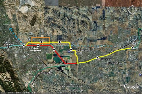
3. The rulemaking pushes cheap not completely dedicated guideway bus projects -

The irony of the cost effectiveness index is that in reality, it fails to capture the full benefits and cost effectiveness of a project. The index evaluates the cost effectiveness of a light rail project versus corridor improvements such as bus rapid transit or improved local bus service. What this does is force cities to choose bus rapid transit projects over citizen -backed light rail projects that may have greater community benefits but also a higher initial price tag. Also, the measurements for the Very Small Starts program are set using the Southtown rapid bus project in Kansas City and not rail or fixed guideway BRT projects such as the Orange Line.

4. The importance of Land Use and Economic Development measures are reduced or ignored by the FTA -

Congress elevated land use and added economic development as project justification criteria in SAFETEA-LU. The US Department of Transportation (DOT), however, ignores this and has combined them into one measure with a combined weight of 20% in the overall rating process. The FTA states that it is too costly to implement the economic development measure but the cost and burden to grantees such as cities and transit agencies is not considered when local jurisdictions are required to adopt the FTA's travel demand models which have many issues. The fact that they use those models to determine the Cost Effectiveness rating which decides who gets funding is a problem in itself as it can't address all the benefits of fixed guideway transit. Furthermore, FTA argues that is too difficult to separate land use from economic development and that the increase in property values associated with proximity to transit is merely a result of improved time savings alone. I'm sure many zoning offices and developers would be surprised to have it categorized so simplistically.

5. Could lower ratings for cities who are trying to address future rather than current congestion issues -

The FTA would like to measure the New Starts program by the benefits to highway users but ignores the idea of induced demand which means when you build a new transit project, the space from cars that are taken off the road by transit is filled by new cars. The want for transit opponents to push money from the transit program into congestion pricing schemes and not so rapid bus projects would result in less useful transit projects in corridors that might have real future need.

Contact Your Congressman or Senators
--Ask them to stop the proposed rule and give the Department of Transportation a clear directive that the FTA Must:

1. Comparably wight all 6 project justification criteria(including: Environmental Benefits, Land Use, Economic Development, Mobility Improvements, etc) recognizing the importance of transit-supportive land use and economic development to fostering successful and sustainable projects rather than just the cost of the project.
2. Maintain the current definition of Fixed-Guideway transit
3. STOP RAIDING THE TRANSIT PROGRAM FOR ROAD PRICING SCHEMES

Tuesday, August 28, 2007

Will Streetcars Replace Buses on the 16th Street Mall?

Denver's 16th Street mall might undergo an extreme makeover. An article in the Denver Post via Denver Infill Blog states:

As Denver's 16th Street Mall approaches its 25th anniversary in October, local officials and business leaders are exploring upgrades that could include replacement of granite pavers in the bus lanes with concrete or even swapping out buses for streetcars.
That would be very cool and would allow the streetcars to be extended eventually to points all over the Denver first ring. Denver Infill even sees a web of streetcars (It would be cool to see a map of this)
Another solution discussed in the article is replacing the Mall shuttle busses with streetcars. This is ultimately the best solution for several reasons. Installing a streetcar line along Colfax has been gaining strong momentum over the past few years, and upgrading the Mall shuttle to a streetcar line would be the logical first step in that direction. With the 16th Street Mall ending right at Colfax, future streetcar extensions east and west along Colfax from Civic Center Station could easily follow. Next, the proposed Downtown Circulator along 18th, 19th, Broadway and Lincoln, could be implemented as a streetcar or, at least, upgraded to a streetcar line as soon as possible, as has been discussed.

RTD is also considering replacing the Welton Street light rail line with a streetcar line, running from the planned 40th & 40th Station down to the 20th & Welton Station, if not all the way to Civic Center Station. RTD also proposed (but dropped from the FasTracks program) a transit connection between the Broadway Station and Civic Center along Broadway/Lincoln. An extension of the Downtown Circulator streetcar line from 12th Avenue to the Broadway Station would be a no-brainer.
Very cool. It will give some of the closer in neighborhood some rail options and possibly connect some of the more vacant large parcels. I also heard something about a perpendicular bus mall to the 16th street mall this week when I was in Denver. Might be an interesting addition.

Also as a side, here are some photos from my few days in Denver.

Here is a sunset picture I took from the Bellview Light Rail Station.

Sunset

Another At Bellview in the tunnel that goes under the road to the elevators. This was really fun with a flash camera.

Transit Art @ Belview

A lot of people use the C Line to get to special events. These folks were coming from a Rockies Game.

Rockies Game Outlet 2

Man I wish the Bellview Station was on the other side of the road. There would have been some great Transit Orientation. You can see the freeway at right. In the photo after, it shows the view from the station (with a cool cloud formation) to the development the transit might have served better.

Southeast Corridor at Bellview

Clouds Over Bellview

There is also no gambling on Light Rail, suprisingly

No Gambling on LRT