Wednesday, December 18, 2013

Neglected Cities Push Certain Transit Because Regional Agencies Won't

In the middle of all the wrangling over the Cincinnati streetcar Peter Rogoff, who is the FTA administrator, said something really interesting in his letter to the city and transit agency. The transit agency (SORTA) is the fiduciary agent for the FTA funding pass through to the city and wants to stay on the FTA's good side since they receive other federal funding. The mayor is looking to kill the project for who knows what reasons he set his mind to, but this is really kind of an aside.  Rogoff:
Transit improvements are best deployed when they are governed and controlled 'under one roof.
He goes on to say in his letter, relayed by the Cincinnati Business Courier
While FTA has been successful in supporting transit projects that are not controlled or operated by the region's principal transit agency, we have found that there are a great many economies of scale that better serve the taxpayer when a fully staffed and experienced transit provider is involved from the very beginning
But isn't that part of the problem?  These massive regional transit agencies are typically stacked with suburban board members that don't always have the core cities needs at heart.  They are usually concocting schemes to extract money or service in some form or fashion from the more transit willing neighborhoods in the region in order to have some sort of suburb to city dream bus or commuter rail line that costs a lot, but really doesn't move the needle on changing mobility in a meaningful way.  Either that or they have to have an election that includes heavy transit opposition precincts that sink ballot initiatives that pass in the city proper.

So recently cities have been taking on the mantle of thinking up and building transit that works for them and their goals.  Portland, Cincinnati, Austin, and others have all taken up planning for more urban transit options and with much different goals.  At the start of the Portland Streetcar process, Tri-Met wanted nothing to do with it.  They were a regional agency.  Right or wrong, the city streetcar movement is a function of the neglect that center cities feel when it comes to regional transit priorities.  The core might be the economic engine for the region, but the fiscal extraction continues.

This is also a disappointing admission that transit agencies and their federal funders still don't know their role in city building.   I'm not talking about building a streetcar and waiting for housing development to come, but rather the need to economically serve, connect, and bolster regional employment centers with workers in a more productive way than the single occupancy car. 

Today an NPR story on Austin popped up with TTI's Tim Lomax stating that it wasn't building roads or transit that needed to change, it was people's behavior. 

But Lomax says his computer models show the only real solution is going to involve changes in behavior and lifestyle. "We did some modeling to suggest the kind of magnitude of change," he says. "We used a giant hammer on the travel model. We took away 40 percent of the work trips. We said those are going to happen somehow, but they're not going to happen in a car." To keep traffic flowing in his sophisticated models, Lomax plays God of Austin. "We said, instead of people driving on average 20 to 25 miles to get to work, now they're going to drive five, six or seven miles to get to work," he says. "That says there's going to be a massive shift in jobs and population."

Emphasis mine.  Those other 40% of work trips that would be needed to keep traffic flowing green (which would never happen - induced demand, duh) would come from walking, biking, and transit because the employment cores were adequately served with good transit. 

What we continue to see today is an overly regional approach to transit development based on a suburban fantasy of living where you want and commuting into work downtown.  Most people don't work downtown.  But intensification of core neighborhoods strengthens the tax base.  So what you get is like what is happening in Minneapolis.  The transit agency is trying to fund commuter service that they call light rail while the city thinks of streetcars because they don't have the funding power to do more.  But there is no talk of dedicated lane surface light rail or subways that only go to the edge of the streetcar suburbs because that doesn't fit each side's worldview. 

The FTA seems to be on the suburban side of the issue, allowing, even wanting, these commuter systems that end up being really expensive to operate (See Northstar in the Twin Cities) with somewhat limited value at this point in their transit network development.  If the FTA can't figure out the suburban leaning of transit agencies or the need to feed employment centers better, we're going to keep traveling down the same choked road, and it won't be pretty. 

Thursday, December 5, 2013

My Basic Reasons Why I like a Guadalupe Lamar Alignment


While I don't quibble with the need for expanded capacity on Riverside, I will argue that Guadalupe/Lamar is a superior route for urban rail in north of Austin's core, over a possible Highland corridor.  I'll let others deal with the methodology issues in Project Connect's selection process, but for me, the data is clear that this corridor is superior for the following reasons...

1.  CORE IS CONSTRAINED

While there are many laudable goals for building urban transit including housing and office development, the main reason for building a rail line is to increase the capacity of a road such that more people can get into a constrained space.  Dan Chatman at the University of California at Berkeley  and others have found that rail's key economic development benefit is serving to increase agglomeration effects in employment centers. 

These agglomeration benefits, as the article states, basically mean the ability to match skilled workers with employers that need them.  Sometimes the definition of economic development gets reduced down to actual development of buildings, but for transit and actual regional economic development, it means much more than that.  Allowing the core to densify and increase the tax base without increasing congestion or at least making travel times reliable, leads to greater access to a skilled workforce at all wage levels.

This is currently happening in the Warner Center in Los Angeles and Tyson's Corner in Virginia.  The constraint to employment center growth is limits on auto access, so now landowners and policy makers introduce high capacity transit to get more people of all skill levels to their jobs and to increase the public and private productivity of the land.

This goal is in tandem to providing affordable housing, mixed income housing, and reducing transportation costs but ultimately it is one of the main reasons to build transit, to continue the increased benefits that downtown's economic engine brings to the city and region as a whole while giving more people access to those benefits.

So if the core is constrained, what is the best way to make travel easier to the most people such that they can reliably access jobs in the core as it grows?  In other words, how do we feed more oxygen into the fire.  Austin's current bus network does a good job of this, but certain corridors are constrained and need to be expanded.  But you can't expand roads in those corridors so you need to expand the number of people who can travel in those corridors, hence high capacity transit. 

2.  RIDERSHIP

The answer to where you'll be able to pull the most oxygen to feed the fire is where they will be the most riders. Riders matter for two reasons, first it makes your line more cost effective from an operational standpoint.  Currently the highest ridership bus line in the city by a long shot is the #1 on Guadalupe and Lamar.  According to data from the service plan 2020 report, this corridor suffers the most in terms of on time performance. In fact that 2010 report noted that the bus was on time only 49% of the time

But the more riders you have on the line, the more you can justify per passenger the operational cost.  Portland has done a great job with their light rail cost efficiency and has proved many times that compared to the bus network, the light rail network is a more efficient way of moving people in and out of downtown.

The second reason ridership matters is that if you're going to be seeking funding from the FTA, you're also going to be competing against every other region in the country seeking federal funds.  In the Transit Space Race report I noted that it would take 78 years to fund all the lines that are being planned with the current federal funding levels of $1.6B per year.  That number has actually been lowered because of a stingy congress, but it's still a very small number, especially when you're helping to build multi-billion dollar subways in New York and San Francisco. 

So what is the best way to win funding?  In part its selling to the FTA that you have all your land use planning in place and have thought a bit about economic development.  But they want to give a project justification rating, an overall rating, and you have to compete with lines like the LA downtown connector that are projecting 16,000 new trips out of 88,000 riders. 

I highly recommend taking a look at other projects that are ahead of Austin in line for federal funds.  Also, going back in time, the Austin line in 1999 scored very high against places that are now built including Houston and the Twin Cities - The Lamar line, which had pieces of the current Metro Rail line would have had 37,000 riders.

So what is the biggest thing that any light rail line can do to get more riders?  Connect people with jobs.

3.  THE IMPORTANCE OF JOBS
Connecting jobs with transit drives ridership.  We know this from research done by Zupan and Pushkarev, Gary Barnes, and UC Berkeley's TOD guru Robert Cervero.  Considering over 59% of transit trips are for work, this becomes an important point.
Pushkarev and Zupan in 1977's Public Transit and Land Use Policy - "Enlarging downtown size or raising nearby residential density. Suppose the options are to double the size of a downtown from 10 to 20 million square feet, or to double the residential density within a few miles of it from 15 to 30 du/acre. The former will increase per capita trips by transit three to four times more than the latter." Many more can be found in this post on the blog

This from Gary Barnes - "Using regression analysis, he showed that in Minneapolis, aside from developing residential densities, transit share can be increased by building up commercial centers. In the regression, he showed that for every 1000 people per square mile that the residential density grew, the increase in transit's share to downtown increased 2.4% versus .6% increase when people went to suburban jobs."

So what does this tell us?  That trips increase when you connect places of density in a city to a strong downtown.  But it's not just downtown that matters, it's all jobs along a line that build ridership.  I created this chart below from my TRB paper on light rail ridership.  It shows new light rail lines that were built in the last 10 years.  What makes their ridership go up?  Connections to jobs. Now in the paper I discuss many of the other issues that folks above mention as well including restricted parking downtown.  But jobs seems to be a clear cut connection that's fairly easy to see, and backed up by a lot of the literature.


https://blogger.googleusercontent.com/img/b/R29vZ2xl/AVvXsEik6XhhFP3wLXWeNfDk7ML0N0If7SqOEfxmIqvZlcws6e7SmQbSUq4VKx3BvPfjx6pD5LdGfXPG0rMFK4f1Xv9TkwxWRXUsXJmS6TquoEL0zYsSFbGjwl3VxwHSIE_GbtmIq55xJp8ueY6g/s1600/TOW1.jpg
So jobs matter for ridership, and connecting more jobs within a half mile of stations will get you more riders.  So ignoring the core of UT, Capital Complex and downtown, where are the most jobs outside of downtown in the northern corridors that are being compared.  Well of course on the Guadalupe/Lamar corridor.  This data was taken from the 2011 census LEHD dataset.  The North Lamar corridor to Crestview has at this present time 46,275 jobs within a half mile.  26,400 of them are people making less than $40k annually.   Contrast that with a likely Highland Corridor, and you see less than half the number of jobs.  Even with rosy projections and development on that corridor, where would 25,000 jobs come from?

This is part of the reason people are so upset at the process and selection.  Sure it's about congestion and redevelopment and serving low income communities.  But congestion is where the jobs are located.  Redevelopment actually happens on light rail proximate to jobs as well.

4.  WHERE DEVELOPMENT HAPPENS ON LIGHT RAIL
We know this because CTOD did a study called Rails to Real Estate, which looked at development patterns along three new light rail lines in Charlotte, Denver, and Minneapolis.  What this report says is that light rail doesn't just create ridership out of thin air, a lot of public policy has to take place but also that the market drives a significant pattern of development. 

There are maps in the report that show where development happened along these lines, but its best to describe it as the employment gravity well.  Basically the market for denser development is in major employment centers, and that market gets extended from the gravity well by the rail line.  It's not just downtown because Denver's line connects the Tech Center, which is the second largest employment cluster in the region, and it saw an uptick in development as well.  Take a look for yourself.  Alignments go away from downtown from left to right.
Twin Cities Hiawatha Line


Denver Southeast Corridor


Charlotte's South Corridor


This is obviously a small sample size of new lines but it is quite instructive.  The location of major employment drives development and redevelopment because the transit is extending the market, not creating it.   Putting a line up into the Highland sector might help spur a small catalyst of development, but its proximity to downtown or a major employment center that matters most.  Guadalupe and Lamar have much more employment along the corridor which is likely to give more people more options to connect with places they work and places they want to go.  But it's the straight line that matters a lot too.
5.  BE ON THE WAY
Anyone who knows Jarrett Walker's work knows that he likes transit lines to be straight.  This causes less schedule disruption and makes the line faster and more reliable.  In the back and forth on twitter he noted the jagged lines that would likely occur if we built the Highland line, especially the section through UT.  You can see in the map above how hard it would be to get from one point to the other without having to make turns somewhere.  But its not straight.
Additionally, we know from UC Berkeley's research that for people to use the train, employment is best closer to the stop, than further away.  People are more likely to use transit for work if it's within a quarter mile, while taking it from their homes is likely to be acceptable to walk a half mile.  This means the route that travels through a less used part of UT, by all the parking garages near the Capital (even though there will be a med school there) and less inviting pedestrian places like Airport Blvd, is less likely to drive ridership.  Now this might be redeveloped in the future.  But we know where people go now, because they take the #1 bus to get there. 

Aerial-Alignments-North

So this is my case. As a national transit advocate, bad decisions in locations make it harder for us to fight for more funding against those who oppose us.  Killer ridership lines are great for beating back the forces against us as well as giving future leaders support for expansion.

Remember
1. The Core is Constrained
2. Ridership Matters for Operations and Funding
3. Ridership is Tied to Employment Location and Density
4. Development and Redevelopment Happens Near Jobs Now
5. The Straight Line is the Best Line

Tuesday, November 26, 2013

Traffic Counts North of the University of Texas


Notice the traffic counts on these corridors.  Also notice how jagged the Red River/Lamar corridor is. As Jarrett Walker says, be "On the Way"

Jobs North of the University of Texas on Two Corridors

Here are the job totals north of the University of Texas along the two corridors.  Guess which corridor the local establishment chose.  Not the one with the most jobs, or low income jobs.  What drives transit ridership?  Employment.

Thursday, August 8, 2013

Twin Cities Alignment Madness and the Perfect Network

I just looked at the number of posts I have in the hopper and its depressing.  I've started a lot of them but haven't finished any of them because I'm trying to address too many issues.  So I thought maybe I should try to keep it a bit shorter (didn't quite work), but not quite twitter short. So a few issues that have been bothering me...

Transit that Tries too Hard

The first issue that's been poking its head out lately is that of the Southwest Corridor alignment in Minneapolis.  It's been driving me nuts for a few years because I'm getting even more tired than I was before of freight rail alignments that are built just because of the cheaper cost.  This should not be just an issue of cost but about the purpose of transit in a system.  Right now it feels like the Twin Cities are just building light rail lines because they decided they want to and it has to serve everyone's politics, which makes for messy and mutli-serving transit that helps less than it should.

Streets.MN has a great number of posts about the background of this on the SW Corridor, but I wanted to focus on two issues in particular.  The purpose of each piece of a transit network, especially the high capacity parts, and the actual alignment of the line.


Transit Building Blocks

Rail lines that are built should have a purpose.  During the regional planning process, corridors should be sussed out based on their need in the overall system, not necessarily because of their technology.  The first reason is that the technology becomes a major issue and argument when people don't quite understand how each works.  And then second, it devolves into a money issue.  It's too expensive!! They cry. 

In the Twin Cities, you have a very low performing commuter rail line with limited service, and a somewhat high performing light rail line that actually acts more like a commuter rail line with greater service frequencies.  The "light rail" line runs down an arterial, operating not like an urban line but more like a suburban line.  It's basically the worst idea of all, putting a rail line in the center of a freeway.

Which, by the way Matthew Yglesias, is a great way to build a transit system that is predestined to not live up to its goals.  This quote "with dedicated busways running in highway medians just as decent light rail lines do" killed me.  Highway medians are a good way to deter transit ridership.  Just ask the Harbor Freeway in LA.  Well that made me mad, along with the rest of the post.  Because the issue isn't bus versus rail.  And don't get me started on the "just like light rail only cheaper" bullshit.  The reason why its cheaper is that you're not doing as much!  But this is a political will issue.

Yes a political will issue.  We should have light rail (and subways) for heavily traveled segments that NEED transit capacity.  This means the places where buses that come often are still sardine tins during rush hour.  Even a place like Geary in San Francisco is an issue for BRT because by the time it opens, it will already be at capacity. Should be a subway.  But we're too focused on cost.

But we do need BRT too!  We should also give priority to buses in places where that means the street will move more people with dedicated lanes.  Take a lane from the car.  But this is the problem, we won't do it, because we won't take that step politically.  Too sacred. Political issue.

But this leads me towards the point I'm trying to make.  David Levinson did a cool thing and overlaid the London Underground onto the Twin Cities geography.  What it also reminds me of, is the fact that European Cities like Budapest and Vienna have subway systems that feed the core circulation, while commuter lines perform a different function of bringing people in from the periphery, skipping a lot of stops in the core, while tramways and buses perform another function on the surface of local stop transit.  This is all to say that each of the transit modes has a specific purpose in the network that we try to cram into a single transit project here in the United States.

In the Southwest Corridor light rail line, just like Mike Hicks mentions, you have an alignment that tries to be a commuter line with light rail technology.  All fine but if you're trying to connect two major employment centers in the American freeway loop, it seems like not just the employment should be connected, but all the major service hungry places on the way that you should be building rail for in the first place.  No more sardine tins at rush hour right?

If I had it up to me, I would build a subway network a la Vienna/Budapest.  Short lines that stay in the historic streetcar suburb core whose endpoints can serve commuter networks and operate inexpensively (because they'll carry so many people) with 2-4 minute headways meaning no one has to wait very long, boosing transit ridership.  In this same area on the surface, create bus lanes for those corridors that need it and build a central station where commuter rail lines and express buses can connect with the places further afield that don't need to be connecting every block with the surrounding neighborhoods.  That's what the surface buses and internal subway network are for.

But that's a dream right?  We live in the right now, and that right now is light rail on freight rights of way. Unfortunately.  Again, we shouldn't be trying to cram three purposes onto one train. 


The Twin Cities Alignment

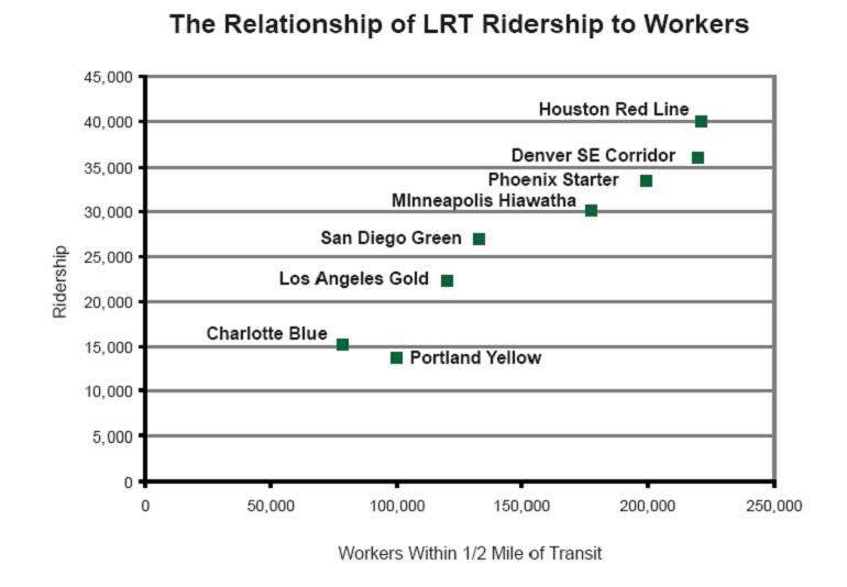
Well if we're stuck in that paradigm we should at least do things right. What drives ridership? Because that's why we're building the line with better capacity, to serve a lot of people who are currently in sardine tins.

According to Gary Barnes (writing specifically about the Twin Cities) and Zupan, it's employment density being served by clustered residential densities.  While the employment provides the ultimate destination which is MOST necessary, riders need to come from somewhere.  So pockets of population density connecting to major employment centers are going to drive ridership, which in turn drives transit success, which in turn drives political will to do more GOOD transit projects. 

So where are we at now?  We're at a place on the Southwest Corridor where a bad decision was made because of the long gone FTA Cost Effectiveness Measure, which has been pushing stupid decisions ever since it was enacted.  The running joke about the model was that the best transit line is one without any stops because it makes the train go faster. But what happens is a lot of freight rail transit lines.  Some aren't too bad like Charlotte where the opportunities are high, but others are kind of lame.

So what was the bad decision in Minneapolis?  Not connecting people with places they want to go.  Or not connecting popular destinations with the people that want to go there.

The biggest trip on transit is the work trip.  59% of transit trips are work trips, meaning that's important to people.  But work destinations are generally those of leisure and convenience as well.  So let's look at the alignment, along with where people who WORK in downtown actually live.

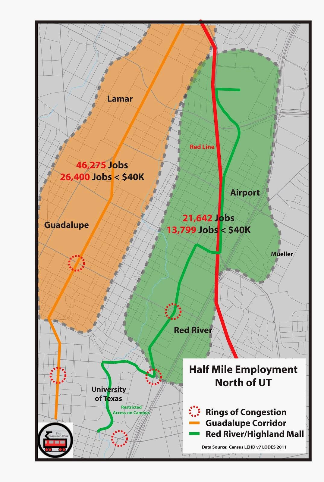
The data below comes from the Census "On the Map" tool, which is an employment dataset with cool mapping features.  Try it out for yourself sometime.

Residential Density of Downtown Workers


People that work downtown live in the area in darker blue along the red line (the line that should be) as opposed to the yellow line (the line that currently is in planning).  1,700-2,700 workers who work downtown per square mile in the areas that are darkest while only 100-400 in the light blue the yellow line occupies.  See how its REALLY light blue.

I'm sorry if the map is a bit ugly, it's late and I wanted to get this out, but hopefully the point comes across.  I don't understand why building something that is useful but a bit more expensive is harder than building something that is of less use.  Perhaps the yellow line would be faster, but that only benefits the suburbs rather than everyone.  Additionally, the people along the red line also have a higher propensity to work in the Golden Triangle further down the line.  See below!

Residential Density of Golden Triangle Workers


The densities are much less as 200-300 people per square mile living in the darkest blue, but its still something more than the current yellow alignment.

And sure, you could say that it matches the residential densities of the place, but that's where high capacity transit should go!  In any event, this is just to show that it seems silly that the corridor of most benefit would be bypassed, when it really should be considered more, if only for its long term value to the region.  Yeah, it will cost more if you want to tunnel, but it will also serve an area that has a greater need, and can create greater value in the long run.

If you learn one thing from this post.  Connecting people to dense employment drives transit ridership, so run the transit from where the people live to where they work in the highest densities.  No brainer.

Wednesday, February 6, 2013

On Charlotte's Fight with North Carolina, Itself


A fight is breaking out between former Charlotte Mayor/current NC Governor Pat McCrory and current Mayor Anthony Foxx over funding related to the local Streetcar and LRT projects.  Charlotte, unlike many other states gives state level full funding grant agreements for capital transit projects. In 1998 Charlotte passed a half cent sales tax for transit expansion in the region with McCrory leading the charge.  In 2007 the pro transit folks fought off another ballot measure to take away the half cent and won by 70% of the vote.  This fight was partly started because of cost overruns that bothered libertarians, also chafing at the thought of having rail in the region.  Apparently the most despised mode of all. 

At this juncture, the city is looking to fund the streetcar project with local property taxes because there is no funding available from the half cent, which is tied up in the Northeast Corridor and operations of the expanded bus system.  The bus system funding has worked so well, that its seen over a 100% ridership increase.  Because of the lack of transit funding, the regional plan as seen below, is taking much longer than initially planned.

2030 LYNX Map thumbnail

This seems to be the rub.  McCrory believes that only the half cent set aside for transit should be used for expansion, and that funding from the state ($299m) is dependent on local funding being so constrained, that the city has to go through the state.  Apparently trying to speed up the process of building out the network by locally funding is not allowed.  One line at a time, and no streetcars. And forget that the roads don't pay for themselves. What this tells us is that decision makers in the state think that if Charlotte has its half cent of play money, the big boys can use the funding for the other interests.

But what else is going on in the region that would equate to other interests?  How about the $3B in road projects that are happening in Charlotte currently.  And they want to start a state fight over a few hundred million?  What a disgraceful flareup.  The State doesn't want to give money because they think Charlotte has enough, and Charlotte with the help of NCDOT wants to waste billions on sprawl highways. Building sprawl highways that have no use until the land around them is developed into oblivion.  Charlotte pretends that it doesn't want to turn into over sprawling and traffic choked Atlanta, but it looks like being Georgia is the goal, and the state led by Pat McCrory, is more than happy to help them get there.

Saturday, January 12, 2013

Grating on a Curve

I was in Houston for a work meeting last spring and went on a tour with our good friend Christof Spieler who has taken a hiatus from blogging at CTC Houston while he is an active member of the board for Houston Metro.  He was kind enough to take me around to a lot of the new construction going on to complete Houston's three newest light rail lines.  I must say I was blown away at the progress and opportunities that the system holds.

Houston's Light Rail Plans via Christof Spieler


North Corridor Construction

I know there is a lot of consternation in Houston from certain congressional parties that if they had it their way would never have let the city build its first line.  But I'm sure glad they did because it's allowed them so much political support to push forward with the system they are installing now.  While even that had its fits and starts as well as issues with general managers and vehicle orders, I firmly believe that this will be the most European system in the United States when completed.

North Corridor Construction

North Corridor Construction

Unlike any other LRT system in the United States, they eschewed existing freight rights of way and made the conscious decision to run in the major corridors with dedicated guideways.  This is going to bring unprecedented mobility to the newly served areas as well as perhaps a few issues as well.

While many say that Houston has no zoning, what it really means is that Houston has no use restrictions.  Unless your neighborhood has existing deed restrictions, anything is fair game as long as it pencils in your pro-forma.  Making that pro-forma more difficult is all of the setback and parking regulations that are required from the city.  It costs a lot of money and changes development dynamics but the lack of use restrictions allow development such as the housing below.  Townhouses on small lots that would never have been allowed in any other single family neighborhood. 


Southwest Corridor in East Downtown (EDO)

East Downtown LRT

This also raises the issue of affordable housing.  While the lack of building restrictions keeps prices fairly low, extremely low in fact when compared to SF or NYC, it doesn't mean that neighborhoods won't see some drastic changes coming to their neighborhoods.


Light Rail Construction in East Downtown

If you would like to see a few more of the images from the trip, check out my Flickr page

Silicon Valley's Transit AND Land Use Problems

There's been a lot of bashing of Silicon Valley lately.  It's the butt of transit jokes because of its light rail line which is one of the least traveled LRT lines in the United States for its distance and service.  At the time it was built, it was one of the first new non legacy lines in the country.  Now that shouldn't be an excuse but we certainly know that in order to be successful you have to connect people with the places they want to go in a timely fashion.  The 1st street line connects a lot of places, but it does it rather slowly.

So we would hope they learned from that mistake when they were planning BART and actually decide to connect places, but give people a faster option, but they decided to double down with aweful all in the same of saving money.  Sure they are saving money using existing ROW for BART, but they are also skipping destinations they need to connect to make it successful. 

Light Rail is Dark Purple, Caltrain is Red, Plannded BART is Steel Blue, Green are areas of high employment density. 


You can see that the planned BART line skips all of the North Valley tech employment and instead makes people depend on a slow light rail system to connect. Even when BART is complete to Berryesa, it won't be as effective as it would have been going under or through this employment cluster into downtown.  Yes it would have cost more but the investment would have been there for hundreds of years. 

Additionally, as I've mentioned in previous posts (1, 2), when silicon valley does get dense, it's in horrible suburban layouts.  You can see below along the San Jose LRT line how buildings suck ridership right out of the system with parking and bad design.


The last image above below shows how many buildings you could fit in this space if they had better non auto oriented design.  And I guarantee this would drive ridership along the line. 

Now there have also been discussions of how Silicon Valley needs to become Manhattan in order to keep talent that wants to live in urban places instead of valley sprawl.  An article in the Awl made this claim but in reality, Silicon Valley doesn't need a hefty core of ultra tall buildings, it just needs to use the space it has better and become the DC or Paris of the Western United States.  There's so much opportunity, yet it is completely wasted. 

So in my eyes the transit is part of the problem for not making the connections that increase property values to do this type of infill, but its also the fault of developers who don't understand that a classic way of building for pedestrians is needed to attract pedestrians and quality of life that people are moving to San Francisco to attain. Sure some people don't want that, but we have more than enough supply of single family homes if there's more of a choice.