Apparently something that draws conservative radio jockeys to that city like moths to a flame. Have you ever wondered about why a fairly dense city with good historic fabric has failed to do any fixed guideway transit planning and is slowly suffocating its bus system because the economy will be so good everyone will be driving cars?
Well Urban Milwaukee has the story and the lowdown on the local politics of transit. It might be similar to the situation in your city. Also if you're interested, check out James Rowen's Political Environment which covers a lot of transit, growth and development issues in the region as well. Great writing going on up there, just wish they could win a few political battles.

Tuesday, July 8, 2008
I Wish They Were All Like This
Man what a great find. Becks over at Living in the O has found the best bus stop mod ever. Check out the photos.
The Indian Electric
It's worth mentioning again Alan Drake's (and others) call for electrification of the freight railroads in the United States. Here's another area though where we are being beaten by other countries. This time its India.
What would the benefits of electrification and a shift of freight to electric rail be? Well Alan says a 6.3% reduction in fuel usage in the United States. With more electric transit and biking incentives it could possibly be even better.Mumbai: In one of the largest deals of its kind, India will buy 660 electric railway engines worth an estimated €3.5 billion (about Rs23,835 crore)....
The engines would be deployed on the dedicated rail freight corrridors India is building, besides hauling cargo on the common rail network. India’s 2,700km-long dedicated freight corridor project was conceived in 2005 as a way to ease traffic on some of the country’s busiest freight routes running through 12 states. The corridor will connect New Delhi in the north to Mumbai in the west and Kolkata in the east. These routes account for 60% of the freight transported by the railways, which had initially estimated the project to cost around Rs28,000 crore.
Monday, July 7, 2008
Replay: The Truth About Roads 6/1/07
An oldie but a good one. I had forgotten about this post but here it is again...
While folks like the Reason Foundation will ask for more roads, it seems to me that they are much more expensive than the transit solutions we are proposing and get to a worse end. Well here is the answer straight from the road kings at the Texas DOT...
Thanks to Andrew for the link.
While folks like the Reason Foundation will ask for more roads, it seems to me that they are much more expensive than the transit solutions we are proposing and get to a worse end. Well here is the answer straight from the road kings at the Texas DOT...
The decision to build a road is a permanent commitment to the traveling public. Not only will a road be built, but it must also be routinely maintained and reconstructed when necessary, meaning no road is ever truly “paid for.” Until recently, when TxDOT built or expanded a road, no methodology existed to determine the extent to which this work would be paid off through revenues.Did you read that like I read that? $2.22 per gallon of subsidization for the road. And this isn't from some liberal think tank or a transit fanatic saying it, it's the organization that builds and collects taxes for them. And this is just the subsidy for the road, not the oil itself! So when simplistic folks from the Reason foundation propose building roads to relieve all congestion, you ask them who is going to be paying for that, or you shut them down with some good research on how much it will really cost versus your transit alternative. It seems to me that even more so now, rail looks even better than ever when it comes to cost effectiveness.
The Asset Value Index, was developed to compare the full 40-year life-cycle costs to the revenues attributable to a given road corridor or section. The shorthand version calculates how much gasoline is consumed on a roadway and how much gas tax revenue that generates.
The Asset Value Index is the ratio of the total expected revenues divided by the total expected costs. If the ratio is 0.60, the road will produce revenues to meet 60 percent of its costs; it would be “paid for” only if the ratio were 1.00, when the revenues met 100 percent of costs. Another way of describing this is to do a “tax gap” analysis, which shows how much the state fuel tax would have to be on that given corridor for the ratio for revenues to match costs.
Applying this methodology, revealed that no road pays for itself in gas taxes and fees. For example, in Houston, the 15 miles of SH 99 from I-10 to US 290 will cost $1 billion to build and maintain over its lifetime, while only generating $162 million in gas taxes. That gives a tax gap ratio of .16, which means that the real gas tax rate people would need to pay on this segment of road to completely pay for it would be $2.22 per gallon.
Thanks to Andrew for the link.
Fantasy Map Fever!
Why do I love fantasy transit network maps? Because unlike bus and automobile, it inspires people to think big and imagine. I think we could use some imagination these days. I've always believed it was good for you.
Charlotte
This map was created in 2005 and sent by reader J. I thought it was a really cool way to show an eventual network that benefits the whole city.
 Sound Transit Maps via Orphan Road.
The Most Recent stuff from Transbay Blog.
Cincinnati maps you can buy on a shirt!
 Brian G. adds Atlanta.
Anyone have any others?
Charlotte
This map was created in 2005 and sent by reader J. I thought it was a really cool way to show an eventual network that benefits the whole city.
 Sound Transit Maps via Orphan Road.
The Most Recent stuff from Transbay Blog.
Cincinnati maps you can buy on a shirt!
Anyone have any others?
A Little West of the Mission
Is where I live. But that's close enough right? With the J just a half block away, the grocery store a half mile away and BART a half mile the other way, what's not to like? Apparently Forbes thinks so as well. The interesting thing though is this:
As some politicians see it, where you live is now a matter of national energy policy. Places with plenty of mass transit and high rates of bicycle usage have received applause from presumptive Democratic presidential nominee Barack Obama on the campaign trail lately. And some on Capitol Hill want to legislate shorter commutes that require less fuel.H/T Commuter Page Blog
Congressman Ed Perlmutter (D-Colo.) recently introduced a bill that would enable home buyers to qualify for lower interest rates on mortgages for homes located near mass transit. Although it isn't expected to get to a floor vote before November elections, it has an ally in powerful House Financial Services Committee Chairman Barney Frank (D-Mass.).
Sunday, July 6, 2008
Oly Trials Update
Awesome! Longhorn and friend Leonel Manzano is going to the Olympics. Congrats Leo and all the folks who are going to represent the US in August. More on Leo from the Austin American Statesman.
Leo on Flotrack
Leo on Flotrack
AirFrance Getting into HSR Business
From Trains for America.
“More than half of all flights are connections, and in effect long-haul is where the value is. Short haul is just way for Air France to get passengers to Charles de Gaulle” airport in Paris, Van den Brul said.
Shifting passengers onto trains from planes would result in “significant” cost savings, a particular concern for airlines struggling to cope with record high oil prices.
Energy accounts for about 40 percent of an airline’s total costs, against only around 10-15 percent for rail.
Can't Find a Map
Someone had either commented or sent me an email with links to a Charlotte Transit map called Queen City Transit. I've searched the comments and my emails and for the life of me can't find it. I wanted to post on it along with some other fantasy maps in other cities that have been floating around. So please comment or send it again so we can share it.
Been Thinking About Transit Density Part 2
So as a continuation of this post on transit density, we're going to look at San Francisco and San Jose. This is not transit density in the usual sense of passengers per route mile as discussed by Mr. Setty at PublicTransit.us but rather station density as discussed by Richard Layman and his oft looked at take on Belmont.
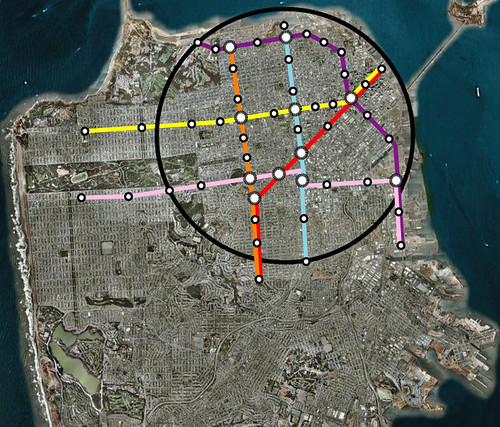
For San Francisco, Eric and others have looked at what a city wide metro would look like. However I thought it would be good to look at it from the standpoint of the sphere I created for the Oakland Map. These aerials are the same dimensions as the Oakland map as are the 5 mile spheres. In the fine grid of San Francisco, you can see that a metro as envisioned below would create a tic tac toe board where getting from destinations all over the densest parts of the city would be fairly easy.
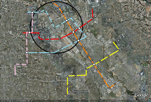
For San Jose though I took a different approach. Instead of using downtown as the center, like Oakland, I thought about how a metro could be used to reconfigure the city and employment districts of Silicon Valley. What came out of it was a more northern sphere centered around west of the airport where there is a lot of land and buildings that could be rebuilt now that their 20-30 year life might be almost over.
It was hard to not try and cover everything instead of focusing on the sphere. These city sphere metro projects could be pretty inexpensive when compared to their resulting benefit which is why its important to think about the area in much smaller terms and corridors.
In San Jose in particular, it grew up in such a spread out pattern, that serving the area, unlike Oakland and San Francisco, would be even more daunting. But its possible to use this metro as a starting point to comprehensive feeder bus and commuter rail system that connects the major cities.
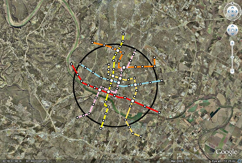
Below is an example of this exercise at build out in Austin at the same scale.
So the point of this exercise isn't to say that these networks should be built with these specific lines, but to show transit density in a core area that would promote the usage of transit in the core while also starting to change the development paradigm. If this type of service were available, walkable neighborhoods would be constructed that have more opportunities to go carless. These networks could also be used as a basis for bike planning.
For San Francisco, Eric and others have looked at what a city wide metro would look like. However I thought it would be good to look at it from the standpoint of the sphere I created for the Oakland Map. These aerials are the same dimensions as the Oakland map as are the 5 mile spheres. In the fine grid of San Francisco, you can see that a metro as envisioned below would create a tic tac toe board where getting from destinations all over the densest parts of the city would be fairly easy.
For San Jose though I took a different approach. Instead of using downtown as the center, like Oakland, I thought about how a metro could be used to reconfigure the city and employment districts of Silicon Valley. What came out of it was a more northern sphere centered around west of the airport where there is a lot of land and buildings that could be rebuilt now that their 20-30 year life might be almost over.
It was hard to not try and cover everything instead of focusing on the sphere. These city sphere metro projects could be pretty inexpensive when compared to their resulting benefit which is why its important to think about the area in much smaller terms and corridors.
In San Jose in particular, it grew up in such a spread out pattern, that serving the area, unlike Oakland and San Francisco, would be even more daunting. But its possible to use this metro as a starting point to comprehensive feeder bus and commuter rail system that connects the major cities.
Below is an example of this exercise at build out in Austin at the same scale.
So the point of this exercise isn't to say that these networks should be built with these specific lines, but to show transit density in a core area that would promote the usage of transit in the core while also starting to change the development paradigm. If this type of service were available, walkable neighborhoods would be constructed that have more opportunities to go carless. These networks could also be used as a basis for bike planning.
Subscribe to:
Posts (Atom)