Showing posts sorted by relevance for query parking. Sort by date Show all posts

Sunday, March 1, 2009

Connecting the Dots

Looks like BART to San Jose has hit another snag because of the economy. The ~20 mile extension from the Fremont station all the way to the San Jose airport via downtown has been delayed for a number of years because of funding issues. Last fall the county passed an 1/8th cent sales tax to fix some of this but according to one analysis it won't be enough. I'm not sure if this is really true because the projections show flat sales tax revenues until 2036, which seems to me to be seriously wrong.
Board members used words like "shocked" and "astonished" at the report by consultant Bob Peskin, who analyzed sales tax projections through 2036. Once inflation is factored out, his sales tax projections are essentially a flat line.
But if true, this comes at the same time as a SPUR report that states suburban job growth imperils emissions reductions due to increased driving. As a practical goal, the region should focus growth in the more urban downtowns and urban areas that aren't office parks.
The city, and other urban areas better served by mass transit than suburban business parks, must adjust policies to attract a greater share of office development and employers, concludes "Recentering Work: The Future of Transit-Oriented Jobs in Downtown San Francisco," released by the San Francisco Planning and Urban Research Association.
So while the BART extension to downtown San Jose might seem like a good idea, its important to note that the round about way in which BART reaches downtown doesn't connect the areas which hold most of Silicon Valley's jobs but rather takes the path of least resistance (ie: existing ROW).

This is a big problem. The line which was conceived many years ago is a continuation of BART and regional authorities poor planning for rapid transit integration with land use. While it might have been state of the art as an idea decades ago, we've learned so much since then about TOD and how connecting destinations strengthens them. No longer will the suburban to urban model work with parking lots catering to the automobile. We need a better analysis of what to do but unfortunately it seems like nothing will stop this move from going through.

The map below shows job density in the valley (From LEHD 2004). Areas with the darkest green are over 20 jobs per acre. But the new BART line (dark blue) touches only the clusters downtown and extension of the VTA light rail line (light purple) go nowhere near the jobs that would attract transit riders.

The VTA Light Rail line hits a lot of the dense job clusters but underperforms because it is seen as slower. I don't know how many people who live in San Francisco have told me that the killer for thier connection to a job in San Jose is the slow round about light rail. This will be the same excuse for BART to light rail on the other side of the Valley.

SanJoseJunk

When we look into these long term Bay Area projects, we need to push planners to think about where people work and where they want to go. It's really important to think about these long term strategies to connect people with jobs and connect jobs to each other. If we're going to be dependent on a knowledge economy here in the bay area, allowing people easy access through transit to amenities and each other is the best way to facilitate energy and emissions reductions. Even if TOD springs up along the new BART line, it won't be as good as connecting the existing clusters of dense jobs with tons of redevelopable parking spaces (see above photo) that might not be needed with rapid transit easily accessible.

Monday, March 28, 2011

Bay Area TOD Policy Might Work

We've had lots of discussions about freeway running light rail and transit and some folks say its ok as long as the major nodes are connected. I probably subscribe to that version, but when it comes down to it I'd rather have the ends of lines not be parking lots. That's why I was glad to see that the BART to Livermore extension was actually going to end in downtown Livermore, not along the freeway. This was thanks in part I believe to the MTC TOD policy, which states that you need to have a certain amount of housing units to build certain technologies like BART. Now of course that policy in itself isn't as powerful as it should be but at least its a good start.

However that won't stop some folks in Livermore from arguing that they thought the line was going down the freeway median all along. What's the point of building a rapid transit line like BART if you're just going to park cars around the stations?! Apparently some people don't get this.
"I guess the thing that's hardest for me to comprehend is that they're putting this train right down the most populated part (of the city) they could come up with,"
Because that's the point! Going to the most populated places so the $3.8 billion line will actually have more riders than parking spaces is the goal. I would personally do it a little differently, but that's just me.

Thursday, August 6, 2009

High Speed Rail for the Masses

Yesterday was such an HSR frenzy that I thought it should be documented:

First, David Lazarus questions whether transit will work in the United States. He talked to some "experts":
He said investments in transit projects need to be accompanied by policies designed to make driving costlier and thus make public transportation more attractive. These policies include significantly higher charges for parking virtually wherever you go and the increased use of toll roads.
I don't like this frame. You mean we need to charge what they really cost. It's not like we would inflate the cost just for the heck of it to some arbitrary number. I guess we could, but really if people just realized how much that garage spot cost or how much the roads really cost things would be much different. Lazarus concludes:
I hate to be cynical, but I simply can't imagine political leaders at the local, state or federal level telling voters that they support a big increase in gas taxes, sky-high parking fees and high-density neighborhoods.
There's a lack of supply of those types of neighborhoods. I really wish people would realize this. It's not that some people don't want to live in these types of environments. It's that for the most part it's illegal. That we need to change.

But a question I had coming out of it is whether HSR can really be called "transit". We don't call air travel transit do we? It seems to me like a kind of grey area. How do you define what transit is and what it isn't. Lazarus was also on NPR's Marketplace.
~~~
The head of Ryanair is obviously going to jump up and down and hold his breath if the UK government states that all short haul flights should be by train. Obviously not all trips can be by train but England really shouldn't be hop skipping inside the country when there is a faster alternative.
~~~
Rob talks Intercity buses. They are cheap and becoming more plentiful. I don't see them being an alternative to rail as some believe. Rob also talks Bent Flyvbjerg. Many people use his work to say we shouldn't do megaprojects. Rob must be back to posting more. Free time?
~~~
That China place is rocking along with their HSR lines. Many places that were super far apart have halfed their travel time between the two. In such a large country, HSR will bring them closer.
~~~
Glaeser. I've heard he's a good economist. How come everything I read from him that's politically tinged is awful. Ryan explains.

Wednesday, July 30, 2008

Replay 7.8.07: Autocentricity in Consumerism

An odd thing happened to me today. I installed Quicken and downloaded my bank data onto my new computer since my hard drive crashed a few months ago. As I was categorizing each purchase, i came to a point where I couldn't find a category to put one of the recurring purchases I was making, BART tickets. There was no section for transportation costs because it was only car costs. There are so many things that go into auto costs including the list below. One thing that I had to add to this is traffic and parking tickets, of which I have gotten a few.

QuickenSS

But what does this say about the overall consumer culture and our debt? Given that the median balance on the American credit card is $1,900, and 43% of Americans spend more than they earn, does this mean we are slaves to our cars?

According to this MSN Money article, the debt of America outside of our Mortgage is largely tied to non-revolving loans like the ones available for people to buy cars. That's just the capital cost for the car. Now what about operating the thing and roads? In 2005, the average American spends 18% of their income on transportation. Recent research suggests that this fluctuates between the exurbs and transit rich urban core with a difference of up to 16% between the extremes of 25% and 9% respectively.

In my own experience, I drive my car once a week and fill up the tank once a month. I probably wouldn't drive at all if my grandmother didn't live so far from BART. Otherwise I take Muni, BART, or walk. I would say that I'm around the 9% in transportation costs which allows me to pay a bit more in rent than I normally would be able to afford. But I'm also able to save up some money.

So in a consumer based, auto oriented society, we are largely tied to our cars, figuratively and sometimes literally. Over the last 60 years we've been so tied down that even personal finance software doesn't give us a transit choice but to enter it in ourselves. But as we've found out from parking, when given the choice for someone to unbundle, a lot of people will choose the alternative because there is one to choose. Someone gave an analogy recently, and forgive me for stealing it if you're reading but if there is a shelf full of only Pepsi how can you say that no one wanted to buy Coke? The choice wasn't there.

Friday, June 8, 2007

Transit Networks & Highwaymen

It seems these days that the folks from the Road cult are squealing pretty loud. I think they are afraid that they will be swept away by the transit space race. While that more than likely will never happen in my lifetime, one has to wonder what they are so worried about. They have after all most of the money for transportation going to roads. It seems to me like a little kid who just can't share his cookies. It's funny too when they cite choices, you can choose a car, or a car. It's your choice. Right?

Wrong.

The fundamental problem with this is that it's exactly what has caused congestion in the first place, letting everyone believe that they are free to have a piece of road at any time without any congestion. In fact some wish that it was in the constitution. Well where is the logic in that? If we look at nature and floods we see what happens when too much water wants to be all in one place. And so it should come as no surprise if everyone took geology or physical geography some time in high school that this would happen. Yet we keep building one mode of transportation. It's kind of like putting concrete at the bottom of a river to channel it. None of it seeps in to the ground just like cars magically get through traffic. And it seems to me that building all of these transitways for buses just encourages more cars. They might have 2 more people in the but its still a car. It's still VMT and pollution and sprawl.

But if you give people a choice they will take it. But it can't be a half cocked choice. Buses in freeway medians in Houston have shown that they only attract so many riders. I have a theory that it's because they travel in the middle of a freeway. Transit is a pedestrian oriented mode. Freeways are not pedestrian oriented. This is another reason why Houston's 5 transit ways garner about 43,000 riders a day while Portland's Max and Streetcar with 5 lines is over 100,000. Per day. It's why the San Diego Trolley is over 100,000 per day. Network and pedestrian orientation are what drives transit, and more freeways amplifies the inhumanities of single occupancy vehicles. 100,000 people in cars is no small amount of extra concrete for roads and parking spaces.

No one was meant to be that selfish every day of their lives. Yes you can be selfish sometimes. I know I am. I drive to my Gramma's house. She lives in the suburbs where the bus stops running at 3:30pm. It's 3 miles from the BART station and while sometimes I walk, some days i just don't have the extra 2 hours to spare (BART is lame in that they won't let bikes on rush hour trains). But everywhere else I walk or take transit whether it's a bus or a train. Tonight I went to concert by taking the J Church to the 45 Union Bus. Powered by alternative energy from Hydro, $1.50, no parking, no hassle. It's the power of networks and human scale quality transit which it seems some of the highway and HOV people miss.

I saw someone somewhere say that the Blue Line in Chicago which has 12 trains per hour could be replaced with an hov lane and 100 buses per hour and this would be revolutionary. I'm not sure what that person was smoking, but it must be bad stuff.

Saturday, April 23, 2011

Transit to Empty Fields

In the United States we haven't been able to talk a lot about transit creating new neighborhoods whole cloth since the early 20th century. Now places like Portland have been able to take abandoned rail yards and turn them into new neighborhoods with a walkable street grid and amenities.

In Europe now, it's being taken even further. Eco suburbs in places like Freiburg are popping up and development is happening as tram lines are planned. The map below from a paper written by Berkeley student Andrea Broaddus shows the expansion of the network.

As an interesting side note, Broaddus' study noted that two ecosuburbs were the same except for parking provisions:
Travel behavior data showed that residents of Rieselfeld had higher rates of transit use in an otherwise typical modal split, while Vauban’s residents had extremely low car share and high bicycle share. These differences were attributed in part to more Vauban’s more restrictive parking policies.
But back to the Reiselfeld. Of interest here is how the development was conceived. The tramway was built before the development and historical Google Earth images show this development happening.

Reiselfeld in 2000


Similar image from a different angle, from The Modern Tram in Europe.

And a more recent image in 2006


To me this is awesome. This is true transit oriented and development oriented transit. Could we ever do something similar here in the United States? It's already happening. Though perhaps not as eco-friendly or dense as would be most sustainable.


Salt Lake City is building the Mid Jordan Trax line into the Daybreak Neighborhood drawn up by Calthorpe. While all the houses are planned to be a five minute walk from local shopping and destinations, there are still a lot of single family homes. Additionally, there is a freeway that is being constructed up the left edge of the valley that will just make Utah's air pollution and inversion days that much worse in the future.

Image courtesy of Calthorpe Associates:


Salt Lake City Suffers from Wicked Inversion Days

Ogden Trip

Flickr Photo via UTA

Mid-Jordan TRAX Segment Map

Daybreak Under Construction - Flickr Photo via Jason S

Daybreak Trax Station

Daybreak Completed - Flickr Photo via Brett Neilson

New Tracks for Trax

All the negatives aside, I think its an interesting experiment and one worth watching. And watch from the air we will...

2003


2005

2006

2009


More Flickr photos at Daybreak from UTA

S70s In The Distance

New Vehicle Testing at Daybreak

And finally a little easter egg for LRT Vehicle nuts.

Sunday, July 8, 2007

Autocentricity in Consumerism

An odd thing happened to me today. I installed Quicken and downloaded my bank data onto my new computer since my hard drive crashed a few months ago. As I was categorizing each purchase, i came to a point where I couldn't find a category to put one of the recurring purchases I was making, BART tickets. There was no section for transportation costs because it was only car costs. There are so many things that go into auto costs including the list below. One thing that I had to add to this is traffic and parking tickets, of which I have gotten a few.

QuickenSS

But what does this say about the overall consumer culture and our debt? Given that the median balance on the American credit card is $1,900, and 43% of Americans spend more than they earn, does this mean we are slaves to our cars?

According to this MSN Money article, the debt of America outside of our Mortgage is largely tied to non-revolving loans like the ones available for people to buy cars. That's just the capital cost for the car. Now what about operating the thing and roads? In 2005, the average American spends 18% of their income on transportation. Recent research suggests that this fluctuates between the exurbs and transit rich urban core with a difference of up to 16% between the extremes of 25% and 9% respectively.

In my own experience, I drive my car once a week and fill up the tank once a month. I probably wouldn't drive at all if my grandmother didn't live so far from BART. Otherwise I take Muni, BART, or walk. I would say that I'm around the 9% in transportation costs which allows me to pay a bit more in rent than I normally would be able to afford. But I'm also able to save up some money.

So in a consumer based, auto oriented society, we are largely tied to our cars, figuratively and sometimes literally. Over the last 60 years we've been so tied down that even personal finance software doesn't give us a transit choice but to enter it in ourselves. But as we've found out from parking, when given the choice for someone to unbundle, a lot of people will choose the alternative because there is one to choose. Someone gave an analogy recently, and forgive me for stealing it if you're reading but if there is a shelf full of only Pepsi how can you say that no one wanted to buy Coke? The choice wasn't there.

Tuesday, February 3, 2015

Talking Headways Podcast: Speeding By Design

This week my guest host Tim Halbur and I chat about how we set speed limits, the design of complete streets for trucks, and the airbnb-ification of parking spaces.  You might also hear some stories about selling parking spaces to fund parties.  Listen in below.

Wednesday, August 27, 2008

Where Else Will It Go?

NBC is planning a massive TOD project on top of the Universal Metro Station. People are complaining about the traffic impacts, but where else is this project going to go? The two office towers worth of employees and studios are going to go somewhere, so why not near good frequent transit? This is the type of development that should be encouraged, however the minimum parking requirements shouldn't. Max out the parking charges and allow people to cash out for transit passes. And Conan O'Brien should ride the Subway to do the Tonight Show when its done.

Saturday, July 5, 2008

Tyson's Corner, Cars

An interesting article on Tyson's Corner from the Washington Post which is in the middle of a fight for a Metro extension. I don't know much about the area, but this article makes Mary Peters and Jim Simpson look ridiculous for trying to kill Metro. It doesn't say anything about it in the article, but this quote tells me a lot.
Tysons' dependence on the automobile, and a place to park it, is dramatic when compared with other areas. With about 120,000 jobs, Tysons features nearly half again as many parking spots in structures, underground and in surface lots. That's more parking, 40 million square feet, than office space, 28 million square feet. Tysons boasts more spaces, 167,000, than downtown Washington, 50,000, which has more than twice as many jobs.
More spaces than jobs? Who pays for all of those? And doesn't that number tell you something about the benefit of good transit? Yup.

Monday, November 17, 2008

Airport Rapid Streetcar?

It seems that BART has decided not to build a People Mover (NOT a light rail system as it says in the article) to Oakland Airport due to cost issues. The route is 3 miles long and while they state that they have already raised $250 million dollars, they still need $130 million more. Are they insane? Would it really take $380 million to go three miles??? A single track BART spur with a passing siding would be cheaper it seems.

If the money is already raised, why not build a rapid streetcar line between the Colosseum and the Airport terminal with limited stops. Currently the bus line comes every 10 minutes or so and actually makes money. One of the reasons is because its so packed all the time. There have been a few times when I have had to wait for 2 buses to pass in order to get to the airport. Even if the separated the streetcar from traffic, it would not cost $122 million per mile.

With the route I've drawn out below, it would promote office development and for more than just airport riders to take the line and provide a direct link to the airport. It would however be a little bit longer at 3.9 miles, but would get its own lanes and have a consistent travel time. I'm also pushing it through the stadiums because at some point, this land will be much too valuable to just leave as a parking lot and should develop more like urban ballparks and stadiums around the country with proximity to transit. This line could also use value capture strategies to fund improvements or the line itself.


At 3.9 miles, you could certainly build the rapid streetcar for the $250 million already raised. I bet they could have some money left over for other projects.

Thursday, December 5, 2013

My Basic Reasons Why I like a Guadalupe Lamar Alignment


While I don't quibble with the need for expanded capacity on Riverside, I will argue that Guadalupe/Lamar is a superior route for urban rail in north of Austin's core, over a possible Highland corridor.  I'll let others deal with the methodology issues in Project Connect's selection process, but for me, the data is clear that this corridor is superior for the following reasons...

1.  CORE IS CONSTRAINED

While there are many laudable goals for building urban transit including housing and office development, the main reason for building a rail line is to increase the capacity of a road such that more people can get into a constrained space.  Dan Chatman at the University of California at Berkeley  and others have found that rail's key economic development benefit is serving to increase agglomeration effects in employment centers. 

These agglomeration benefits, as the article states, basically mean the ability to match skilled workers with employers that need them.  Sometimes the definition of economic development gets reduced down to actual development of buildings, but for transit and actual regional economic development, it means much more than that.  Allowing the core to densify and increase the tax base without increasing congestion or at least making travel times reliable, leads to greater access to a skilled workforce at all wage levels.

This is currently happening in the Warner Center in Los Angeles and Tyson's Corner in Virginia.  The constraint to employment center growth is limits on auto access, so now landowners and policy makers introduce high capacity transit to get more people of all skill levels to their jobs and to increase the public and private productivity of the land.

This goal is in tandem to providing affordable housing, mixed income housing, and reducing transportation costs but ultimately it is one of the main reasons to build transit, to continue the increased benefits that downtown's economic engine brings to the city and region as a whole while giving more people access to those benefits.

So if the core is constrained, what is the best way to make travel easier to the most people such that they can reliably access jobs in the core as it grows?  In other words, how do we feed more oxygen into the fire.  Austin's current bus network does a good job of this, but certain corridors are constrained and need to be expanded.  But you can't expand roads in those corridors so you need to expand the number of people who can travel in those corridors, hence high capacity transit. 

2.  RIDERSHIP

The answer to where you'll be able to pull the most oxygen to feed the fire is where they will be the most riders. Riders matter for two reasons, first it makes your line more cost effective from an operational standpoint.  Currently the highest ridership bus line in the city by a long shot is the #1 on Guadalupe and Lamar.  According to data from the service plan 2020 report, this corridor suffers the most in terms of on time performance. In fact that 2010 report noted that the bus was on time only 49% of the time

But the more riders you have on the line, the more you can justify per passenger the operational cost.  Portland has done a great job with their light rail cost efficiency and has proved many times that compared to the bus network, the light rail network is a more efficient way of moving people in and out of downtown.

The second reason ridership matters is that if you're going to be seeking funding from the FTA, you're also going to be competing against every other region in the country seeking federal funds.  In the Transit Space Race report I noted that it would take 78 years to fund all the lines that are being planned with the current federal funding levels of $1.6B per year.  That number has actually been lowered because of a stingy congress, but it's still a very small number, especially when you're helping to build multi-billion dollar subways in New York and San Francisco. 

So what is the best way to win funding?  In part its selling to the FTA that you have all your land use planning in place and have thought a bit about economic development.  But they want to give a project justification rating, an overall rating, and you have to compete with lines like the LA downtown connector that are projecting 16,000 new trips out of 88,000 riders. 

I highly recommend taking a look at other projects that are ahead of Austin in line for federal funds.  Also, going back in time, the Austin line in 1999 scored very high against places that are now built including Houston and the Twin Cities - The Lamar line, which had pieces of the current Metro Rail line would have had 37,000 riders.

So what is the biggest thing that any light rail line can do to get more riders?  Connect people with jobs.

3.  THE IMPORTANCE OF JOBS
Connecting jobs with transit drives ridership.  We know this from research done by Zupan and Pushkarev, Gary Barnes, and UC Berkeley's TOD guru Robert Cervero.  Considering over 59% of transit trips are for work, this becomes an important point.
Pushkarev and Zupan in 1977's Public Transit and Land Use Policy - "Enlarging downtown size or raising nearby residential density. Suppose the options are to double the size of a downtown from 10 to 20 million square feet, or to double the residential density within a few miles of it from 15 to 30 du/acre. The former will increase per capita trips by transit three to four times more than the latter." Many more can be found in this post on the blog

This from Gary Barnes - "Using regression analysis, he showed that in Minneapolis, aside from developing residential densities, transit share can be increased by building up commercial centers. In the regression, he showed that for every 1000 people per square mile that the residential density grew, the increase in transit's share to downtown increased 2.4% versus .6% increase when people went to suburban jobs."

So what does this tell us?  That trips increase when you connect places of density in a city to a strong downtown.  But it's not just downtown that matters, it's all jobs along a line that build ridership.  I created this chart below from my TRB paper on light rail ridership.  It shows new light rail lines that were built in the last 10 years.  What makes their ridership go up?  Connections to jobs. Now in the paper I discuss many of the other issues that folks above mention as well including restricted parking downtown.  But jobs seems to be a clear cut connection that's fairly easy to see, and backed up by a lot of the literature.


https://blogger.googleusercontent.com/img/b/R29vZ2xl/AVvXsEik6XhhFP3wLXWeNfDk7ML0N0If7SqOEfxmIqvZlcws6e7SmQbSUq4VKx3BvPfjx6pD5LdGfXPG0rMFK4f1Xv9TkwxWRXUsXJmS6TquoEL0zYsSFbGjwl3VxwHSIE_GbtmIq55xJp8ueY6g/s1600/TOW1.jpg
So jobs matter for ridership, and connecting more jobs within a half mile of stations will get you more riders.  So ignoring the core of UT, Capital Complex and downtown, where are the most jobs outside of downtown in the northern corridors that are being compared.  Well of course on the Guadalupe/Lamar corridor.  This data was taken from the 2011 census LEHD dataset.  The North Lamar corridor to Crestview has at this present time 46,275 jobs within a half mile.  26,400 of them are people making less than $40k annually.   Contrast that with a likely Highland Corridor, and you see less than half the number of jobs.  Even with rosy projections and development on that corridor, where would 25,000 jobs come from?

This is part of the reason people are so upset at the process and selection.  Sure it's about congestion and redevelopment and serving low income communities.  But congestion is where the jobs are located.  Redevelopment actually happens on light rail proximate to jobs as well.

4.  WHERE DEVELOPMENT HAPPENS ON LIGHT RAIL
We know this because CTOD did a study called Rails to Real Estate, which looked at development patterns along three new light rail lines in Charlotte, Denver, and Minneapolis.  What this report says is that light rail doesn't just create ridership out of thin air, a lot of public policy has to take place but also that the market drives a significant pattern of development. 

There are maps in the report that show where development happened along these lines, but its best to describe it as the employment gravity well.  Basically the market for denser development is in major employment centers, and that market gets extended from the gravity well by the rail line.  It's not just downtown because Denver's line connects the Tech Center, which is the second largest employment cluster in the region, and it saw an uptick in development as well.  Take a look for yourself.  Alignments go away from downtown from left to right.
Twin Cities Hiawatha Line


Denver Southeast Corridor


Charlotte's South Corridor


This is obviously a small sample size of new lines but it is quite instructive.  The location of major employment drives development and redevelopment because the transit is extending the market, not creating it.   Putting a line up into the Highland sector might help spur a small catalyst of development, but its proximity to downtown or a major employment center that matters most.  Guadalupe and Lamar have much more employment along the corridor which is likely to give more people more options to connect with places they work and places they want to go.  But it's the straight line that matters a lot too.
5.  BE ON THE WAY
Anyone who knows Jarrett Walker's work knows that he likes transit lines to be straight.  This causes less schedule disruption and makes the line faster and more reliable.  In the back and forth on twitter he noted the jagged lines that would likely occur if we built the Highland line, especially the section through UT.  You can see in the map above how hard it would be to get from one point to the other without having to make turns somewhere.  But its not straight.
Additionally, we know from UC Berkeley's research that for people to use the train, employment is best closer to the stop, than further away.  People are more likely to use transit for work if it's within a quarter mile, while taking it from their homes is likely to be acceptable to walk a half mile.  This means the route that travels through a less used part of UT, by all the parking garages near the Capital (even though there will be a med school there) and less inviting pedestrian places like Airport Blvd, is less likely to drive ridership.  Now this might be redeveloped in the future.  But we know where people go now, because they take the #1 bus to get there. 

Aerial-Alignments-North

So this is my case. As a national transit advocate, bad decisions in locations make it harder for us to fight for more funding against those who oppose us.  Killer ridership lines are great for beating back the forces against us as well as giving future leaders support for expansion.

Remember
1. The Core is Constrained
2. Ridership Matters for Operations and Funding
3. Ridership is Tied to Employment Location and Density
4. Development and Redevelopment Happens Near Jobs Now
5. The Straight Line is the Best Line

Sunday, September 14, 2008

Possible Streetcar Network Funding Idea

As cities look to build streetcars, its easy to come up with an initial amount from businesses but its that last few million that seems to be troublesome. A lot of cities look to TIF funding, but that source of funding has limits and many want to use it for different purposes including affordable housing and basic infrastructure such as water/gas lines and sidewalks.

So here I'm about to toss out another crazy idea that I'll need help from my economist friends to see if it is really possible to do. I'll use the Minneapolis streetcar network plan as an example. We know there is not enough funding to do it all at once. If we use Detroit's recent fundraising success from local businesses as seed money, one corridor exists to fuel the others. The fueling is in real estate transfer taxes off of the increase in value that is created by the new streetcar line. Since infrastructure such as the streetcar has been seen to add value, it's only fair that some of that value be reinvested in other areas that will receive similar infrastructure. So bear with me here as I go through the process.

1. Do an initial study to figure out the streetcar network. Once completed this will serve as the base funding area for engineering. A basic TIFF district for the whole in town streetcar network would serve as a base for the rest of the plan. The district boundaries will stay because they will be used later.

2. The Detroit instance shows that businesses and foundations are interested in their cities future. They have raised 75% of an initial $100 million in Capital Costs for a new line down Woodward. The first line should try to pull in money from outside entities and use that line to feed the others.

3. Before the first line is constructed though, a baseline is set on real estate costs in the area defined by the very small increment TIF district that was initially used for the engineering studies. This baseline would be used to calculate a real estate transfer tax that allows the streetcar network to capture the value of rising real estate values along the line. There should also be a transportation fee for new square footage. I believe that San Francisco for a long time had a fee that went to Muni at 5$ for every new square foot in a building. These linkage fees could be tied to parking reductions so its not as much of a burden on the developer, and leaves money for other endeavours such as affordable housing.

4. After completion of the first line using funding raised locally, the rising coffers funded by the transfer tax and linkage fees from the first investment go into the construction of the second line in the district. Once the second line is complete, the real estate around that line goes to the third line and so on starting off a chain of funding that creates the network. Over a 20 year period, I believe it would be possible to build each line.

I also think that if a plan like this was created, it would create more incentive for the federal government to help out if this were tied to a national strategy. So there is the idea. Funding one line at a time by fueling one line at a time as a primer for the next one.

Minneapolis Planned Streetcar Network

Sunday, March 1, 2015

Podcast: Ann Cheng Discusses GreenTrip

This week on the Talking Headways podcast, Ann Cheng from Transform joins me to talk about how developers can lower their parking obligations through Green Trip, a certification program for development in the Bay Area.


~~~
Need more news about cities daily?  Sign up for the Direct Transfer.

Saturday, October 11, 2008

Fleet Week Awesome. Muni FAIL

Today was an awesome day on the North end of the city that started with Texas(5) beating Oklahoma(1). I watched from a bar on Union Street with about 200 Texas exes and friends. Then I went with some friends to watch the Blue Angels fly over San Francisco at varying angles. All of this was great and made me pretty tired but glad I got out today. It was an amazingly beautiful day.

On the other hand. It was an epic epic Muni FAIL. In my first year here. I made the mistake of driving the 3 miles North to watch the football game during fleet week. Bad idea. No parking (when is there ever?) and traffic you wouldn't believe. The last few years, I've decided to take Muni which I try to do as much as possible. This morning I would take my usual J to 22 connection. But it started out badly. When I left my house, the NextMUNI webpage said 3 and 15 minutes for the J at 24th and Church. I got to the stop and the 3 min J was just leaving. I felt that was ok. 10 minutes wasn't bad and I would be a little late to the game but no problem right?

Not right. I waited 25 minutes for the J and the driver was chatting away with what seemed like a supervisor with a yellow MUNI vest. I was already annoyed that they were 15 minutes late and the talking really wasn't doing much harm, but because they were late more people had gathered meaning more people had to pay as they entered which always slows the whole process down. And why they have so many stop signs on Church I'll never know.

So i get to Duboce and Church where I would hop on the 22 and the next one comes in 12 minutes. It's already 9am and the game starts at 9am. I wait 12 minutes and off we go. The 22 gets there and I'm responding to texts from my friends telling them I'll be a little late but not too bad. Then some crazy stuff happens. The driver decides that at stop lights he'll read the SF Chronicle. And at one point he hops out of the bus at a stop and walks into a store to pick up a sandwich. What?!

Obviously I was annoyed. I was already late because of Muni. But this was ridiculous. So what would have taken me about 15 minutes in a subway or a car took me an hour on Muni. I know this is the reason people drive. It annoys the heck out of me that we can't get it right. Between the late train and the crazy bus driver...it was enough to make me almost declare war on Muni.

The way home pretty much sucked as well. So much traffic on Van Ness (I walked that way to see the ships from Fort Mason) I decided to go back to the 22. Well I got passed by three full buses and ended up just walking the 2 miles to the J. It was ok though. I got to take some pictures on Union Street. But for the once in a while rider, that day would probably kill your riding for about a year. Cabs it is!

In any event. This needs to be improved. And the TEP would really do almost nothing to change that trip. BRT on Van Ness could possibly help that trip but honestly there needs to be an east west and north south subway. I should be able to get anywhere in a 7 mile by 7 mile city in 30 minutes. That should be the goal. That would be quite impressive mobility for here and guess what, more people would take transit!!!

Here are some pictures and movies. The first one shows the final seconds of the game at the Blue Light bar. Pretty exciting.


The following pictures are of the Fleet Week traffic...

Van Ness

Van Ness Traffic

Lombard

Lombard Fleet Week Traffic

North Point Street

Muni Bus Bunch

People Traffic and Ships!

Fleet Week Ships

Marina Street - They would be dumb not to put the future F Line extension to the presidio in its own lane when you see this:

Marina Street During Fleet Week Traffic

Union Street Life

Union Street Street Dining

Tuesday, July 19, 2011

Bad Employment Location Decisions

Annoying me to no end are decisions to locate major new employment opportunities in areas that have no access to regional rapid transit.  The most recent of these is the idea that Berkeley Labs would take the Golden Gate Fields horse racing track and redevelop it to bring all the employees together that were once in different places. 


This is a laudable goal however it's right next to a major freeway and will basically add more transportation costs to the University, AC Transit district while also increasing auto traffic (A mention of 2,500 cars).  I'm sure my taxes will have to pay for that stupidity.  Apparently downtown Oakland isn't good enough. 

I think Auto Row might be a good location for this campus, right next to Pill Hill and Kaiser hospital.  There's plenty of space for a few tall buildings, its ripe for redevelopment because of all the parking lots, and its on a major transit route, and fairly close to BART.  Another good place would be downtown Oakland.  There's plenty of space if they really took a look.  People seem to be lazy and look for what amounts to an urban greenfield.  They really need to get an imagination. 

Thursday, July 10, 2008

EPA, Regressive Progressives, A Green Link

The EPA is saying that the EIS for the Columbia River Crossing doesn't consider growth from Sprawl or water and air pollution caused by increased driving. Don't get me wrong, I think its important to look at these things but the EPA has been super schizophrenic as of late. Perhaps this is the wing of the EPA not controlled by Bush lackeys? You know, the ones that reduced the value of life...really. From the Oregonian:
The critique is drawn from EPA's review of the Columbia River Crossing's 5,000-page environmental impact statement, and it extends to other areas as well. Among those are whether doubling the congested I-5 bridge from six to 12 lanes will promote suburban sprawl; whether the combination of air toxics, noise and other pollution will punish North Portland communities living close to the I-5; and whether massive pile-driving efforts will stir up toxic sediments, compromising federally protected migrating salmon.
In other environmental news from the bay area, BRT booster Charles Siegel writes a fairly scathing critique of Berkeley residents which has become a city of regressive progressives r.
These hard-core anti-environmentalists seem to believe that they are fighting to protect Berkeley’s character against growth. They don’t realize that Berkeley’s early character as a walkable streetcar suburb was disrupted by auto-oriented development. Transit corridors were filled with drive-in uses, and they ended up being more like strip malls than like walkable Main Streets. Even in downtown, there were surface parking lots, tire stores, a strip mall, a car wash, and other drive-in uses that made it less pleasant to walk.
Obviously I'm not a fan of BRT in these corridors that used to be Key System lines, especially when its not electrified but the grounds on which this proposal is being opposed is a bit silly. It makes Berkeley residents look bad. Eric covers the worst of it.
Meanwhile, one quite confused speaker claimed that giving buses a dedicated lane would cause them to “get stuck,” and that what we really needed was “flexibility.” She suggested that with “flexibility,” AC Transit could run buses every three minutes, while implying that three-minute headways would be impossible with a dedicated bus lane. Just incredible.
It's at this point when you kind of just have to throw up your hands and say uncle. These people are never going to get it. And its sad, because even though BRT is a small step up in service, it represents a giant shift in priorities (people over cars) and better service than what exists now.

And Green News from BART, all of their peripheral systems are going solar. Pretty cool.

Sunday, April 1, 2012

Austin's Rail History & Route Choice Problem Part 1: History


This last week there have been flurries of articles and tweets about a subject that is near and dear to my heart.  Austin's push for rail transit was the reason I started thinking about these issues and part of the reason why I started this blog.  I even wrote my Master's Report (Source of some of the Timeline below) on the politics and history of this movement that has caused so much consternation to local advocates since the early 80s. 

I've written about these issues in Austin many times before. (Alignment, VMT Reduction, and Starter Technology Decisions)   Some of you might be getting sick of my Austin posts, but ultimately the point of this blog is to bring information to the forefront and get folks to think about the decisions they are making about transit and technology.

This is going to be a multi-post series so first let's go through the basics.  Let's do a timeline to catch you up quickly...


1960s -  In the 60's, as happened all over the country, major arterials in cities were slated to become freeways.  While many cities built an initial freeway network and loop roads, Austin's neighborhoods pushed back on getting sliced in half and limited freeway development to two major north/south corridors and East/West corridors that were far away from the city center, making arterial streets the major corridors.  Texas Freeway has historical pictures and documents. This meant that getting east to west in central Austin has to be done on surface streets. 

1973 - The Texas State Legislature, understanding that regions were growing and cities alone were too small a jurisdiction to support regional transit systems, passed a law allowing Metropolitan Areas over 600k people create a Metropolitan Transportation Authority (MTA). At the time Austin did not have enough population.

1981 - Austin lobbies successfully to get State Legislature to allow cities over 325k people to get an MTA.

1983 - An interim agency named the Austin Area Rapid Transit System was created to be the predecessor to the RTA. A Transit service plan created in 1984 consisted of a short and long term plan.  The short term was for increases in bus service as the long term consisted of rail planning. As part of the long term rail planning for the RTA, the agency began discussions to purchase existing freight rights of way from Southern Pacific.  Additionally, there were discussions on forming a Metro Government and a bill was written by Representative Terrel Smith but never filed.

1985 - Replacing the Austin Area Rapid Transit System, Capital Metro Transportation Authority (Capital Metro) was created and given the ability to levy a cent sales tax, which was chosen instead of an emissions tax or a gas tax increase.  The first day of service and the resulting bus parade down congress made a lot of locals angry, and set Capital Metro off on the wrong foot with many at the local level as well as the state. 

1986-87 - Flush with cash from the cent sales tax, Representatives in the Legislature started trying to redistribute half the sales tax value that was being saved up for future rail construction.  Representative Terrel Smith sought to give the half cent back to relieve property taxes in the district.

1989 - Board members voted to reduce the sales tax a quarter cent to quell criticism.  While rail supporters wanted Capital Metro to keep saving for a future rail plan, others such as Travis County wanted the extra money to pay off road debts.

1990 - Funding was allocated to study rail in Austin and the board stated that a referendum would be had if they got a positive outcome from the study.  A referendum was pushed back but CAMPO put rail planning in its long range plan that year.  That very same year was the break out of Austin's growing environmental movement.  Tired of seeing developers ravage the land above the Edwards Aquifer and its recharge zones, Austinites came out in droves to an all night meeting that saw the end of a single Barton Creek Planned Unit Development, but a start to the environmental machine in Austin politics. 

1995 - Planning for a rail line, the board decided to raise the sales tax back up to a cent, which drew criticism from enemies still existing including Gerald Daugherty.  Even though an overwhelming amount of the speakers at the meeting spoke on behalf of the increase, the Austin American Statesman and others criticized the board for not having a referendum in place for rail before making the vote.  The general manager even decided to leave when the Statesman kept going after the agency

1997 - Because of accountability issues stemming initially from the board vote on the tax increase, the Legislature decided to restructure Capital Metro's board.  This would not be the only time the board structure would be changed. Instead of a citizen board, it would be populated by elected officials, who would be seen as more accountable to the public.  Additionally, Representative Sherri Greenburg passed a bill in the legislature that would require a referendum before the agency would be allowed to issue debt. At the same time, planning for a commuter rail line that looks like the current one would be studied, as well as others that look a little familiar.

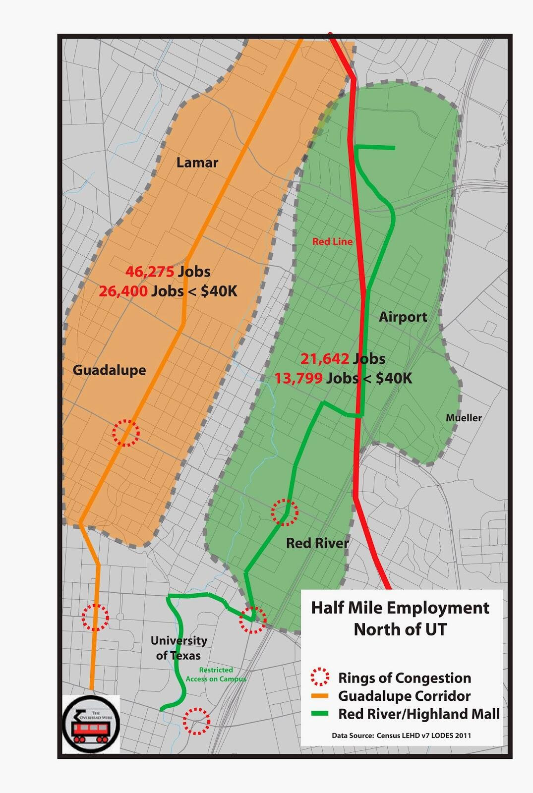
1998 - With a restructured board and possible bills that would strip Capital Metro of its cent sales tax coming at an even faster pace, rail was considered again and consultants came up with the idea for the Green Line, which would go directly through the heart of Austin.  The line was supported more than the Red Line, which would circumvent major destinations downtown but would be cheaper due to its route on existing rights of way.  It was at this point that Capital Metro started officially stashing away money to pay for future rail construction. 

1999 - Capital Metro promised legislators who continued to write bills to take funding away from the agency that they would have a referendum in 2000. Representative Mike Krusee from Round Rock and others including Representative Terry Keel continued to hammer the agency and push bills that would take away funding authority.  Krusee's bill would require a referendum on half of the sales tax, essentially stripping Capital Metro of its ability to save money for rail plans.  This was also the year that Austin Bergstrom Airport was completed and the Mueller Airport, a few miles outside of downtown on the east side was left open for redevelopment. Planning included future stops on a yet to be named rail line.

2000 - The decision was made to have the referendum during the 2000 presidential election, in which Texas' Governor George W. Bush was on the Presidential ballot.  The hard fought contest brought out the anti-rail groups in droves, with Texas getting special visits from Wendell Cox and others to push for the rail line's failure with the hope that the extra money would go to roads.  Kirk Watson, then Mayor even wanted to put road bonds on the ballot to satiate the Road Warriors but anti-rail leaders like Gerald Daugherty wanted rail money for roads, claiming other bond money would be insufficient.

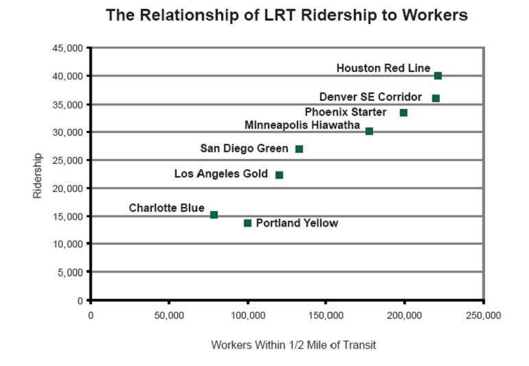
Before the election, the Federal Transit Administration gave its stamp of approval, saying other cities would be in line for New Starts funding behind Austin in the process due to the high ridership drivers.  2025 estimates put the ridership estimate at 37,400 riders (17,000 new).  Consequently, some lines from that FTA PE class (no pun intended) have gone on to be super successful, including Minneapolis' Hiawatha Line, Cleveland's Euclid BRT Line, Denver's T-Rex Line, Houston's Main Street Line, Portland's Interstate Max, and Seattle's Central Link.

But even after choosing the correct route and a majority of City of Austin residents voting for the line, the Capital Metro service area voted against the proposal.  The rail vote lost by less than 2,000 votes in a Presidential Election which had over 300,000 voters.  By that time, Capital Metro had saved over $120m for rail construction. Mike Clark Madison (Who wrote many of the linked to articles above) documented the spatial approval over at the Chronicle.

2001 - After the election, to quell mounting pressure from the legislature, Capital Metro decided to rebate a quarter cent that had been saved up back to the cities for mobility projects.  The agency continued to plan for light rail and a deal was brokered between Representative Krusee, who was the Chair of the Transportation Committee, and Capital Metro which resulted in a bill that would require Capital Metro to rebate the quarter cent until a referendum was passed.  Additionally, Representative Krusee helped to get a bill pass that would establish Regional Mobility Authorities (RMAs) that would give locals more authority to build toll roads. 

2002 - Karen Rae, who had signed on to be Capital Metro's general manager in 1998 and make the push for rail stepped down and Fred Gilliam took on those duties.  Planning for light rail continued with a new name (Rapid Transit Project) however it was decided that a referendum would not be held in 2002 due to a lack of consensus for the project.

2003 -  Representative Krusee, who had been named Chairman of the State Transportation Committee,  had his own ideas about what the next rail plan should look like.  The Austin American Statesman suggested that he would like Capital Metro to stop studying the Green Line corridor and focus on the Red Line, which consultants had chosen against in planning for light rail in 1998.  In 2000, the Austin American Statesman, quoted Krusee as saying "I wish they would be open to alternatives to light rail"  We know now that meant planning for light rail along the best possible corridor would stop and planning for a corridor that went directly to his constituents in Round Rock (which doesn't pay into Capital Metro) would commence. At the same time, Envision Central Texas was having its coming out party as a way for the Austin region to organize itself.  Unfortunately unlike Utah's process, teeth were not present.

2004 - Planning for light rail on the Guadalupe corridor stopped sometime in January.  Campus planners at the University of Texas stated they stopped hearing from Capital Metro at that point.  Route choices considered at the time were down San Jacinto street, on the other side of campus from Guadalupe, because UT considered San Jacinto to be the center of an expanding campus.  The push for rail on the other side of campus would continue to today.  Later discussions from interim CEO Doug Allen in 2009 suggested that there was not enough time to get an adequate cost estimate and firm up engineering before having the election.  He also believed that the line should have been double tracked at a potential cost of $300 million per mile to build it out properly, likely to not have to worry about retrofitting the line at a future date. 

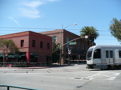
In March of 2004, Commuter Rail was announced the community and Capital Metro planned for a referendum during the Presidential election that fall.  Advocates pushed for streetcar connections and other alternatives, but changes to the commuter rail plan were set by Capital Metro and planners for the agency after a few discussions were not allowed to interact with staff as they wanted to keep the line as bare bones as possible to court a winning vote.  Lee Walker, then Chairman of the board, believed that going over $60m for the cost of the system would be too much for the voters and Representative Krusee hinted at the time that he would be able to get the voting requirements for extensions rescinded if the rail system was kept to just the commuter rail line.  The line passed in a referendum that fall with 62% of the vote (operations began in 2010).  Contrary to the previous election, neighborhood groups on South Congress and others were not as active in opposition because they wouldn't see transit construction on their streets.

Also after the election, the Mueller Airport Master Development Agreement was signed, which would determine the terms of the redevelopment of the airport property that left over a large amount of empty land proximate to downtown.

2005 - The thought in the transit community was that 2004 would be the last chance to pass a rail referendum in Austin.  Once the line was passed, it was believed whether right or wrong, that it could be fixed with extensions and additions such as streetcars.  Capital Metro went on to study streetcars. In addition the the commuter line which was the center piece of the 2004 election, the All Systems Go plan also included BRT corridors and enhancements.  Planning for those corridors began in earnest as well.

2006 - Streetcar planning continued and a route was chosen through an alternatives analysis.  Pushes to get the Mueller redevelopment into the mix created a route the connected downtown with the east side of the state capital full of parking garages, the University down San Jacinto street through the stadium complex and out towards Mueller.  As for Rapid Bus, some finally started to take note that getting the FTA to buy new buses and shelters without giving the line a dedicated lane was not really rapid.  Council Members Brewster McCracken and Lee Leffingwell pushed back on the idea and asked the agency more questions. 

2007-08 - CAMPO, the regional MPO for the Austin area decided to take major rail planning away from Capital Metro for the time by creating the transit working group (TWG).  The 15 member group would be made up of State Representatives, State Senators, Mayor Will Wynn, advocates, the University of Texas, and other groups.  This was on the heels of Wynn calling for a rail election in 2008, though as with most every other call for election in Austin's early rail history, that idea would not come to pass.  At this point the streetcar plan began its metamorphosis into the urban rail plan, with ROMA design taking up planning for alignments and continuing to push a Mueller alignment while also bringing in a Bergstrom Airport/Riverside alignment that was similar to other plans in the 1990s.  ROMA was attached to this planning because of their initial task of creating the Downtown Austin Plan.

2009-10 - Planning continued on Urban Rail and more alignments were discussed but it failed to go to the ballot again due to the lack of a financial plan.  Capital Metro, once rolling in cash, had drawn down its reserve to build the Red Line and thus stopped funding mobility projects with the quarter cent. (The sordid background tale is here).  Also, another state audit brought more news that the agency had been mismanaged under recently retired Fred Gilliam's watch and the board was restructured again to include someone with financial experience.  At this same time, Capital Metro did its first ever look at all the routes in the bus system calling it 
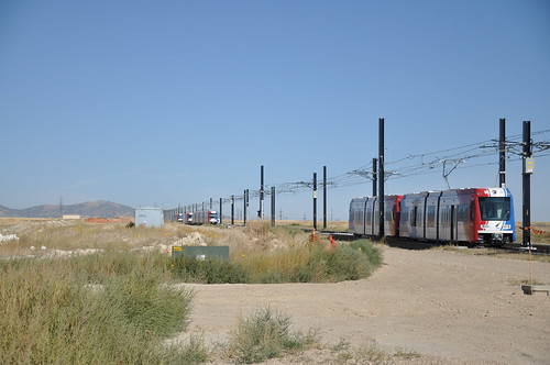
service plan 2020.  Ridership along the 1 route continued to outpace all others with over 17,000 including the 101 that will soon be replaced by 'Rapid Bus'. That is more than double the next highest ridership non UT line (7). The long awaited Red Line would open in 2010 to service just under 1,000 riders.

2011-2012 - And here we are. Still planning for urban rail and still trying to figure out how to pay for it.  The TWG continues to look at different corridors while the city focuses on Urban Rail.  In February, Todd Hemingson laid out the process at the TWG for planning future corridors but still not much mention of the most congested and highest ranking ridership corridor in the region. 

Ok, so, I apologize in advance if I missed something about the history above.  It's totally possible (I know there must be something missing) that I did considering the number of years and number of times rail has been close to being on the ballot, new alignments were drawn out etc.

 But here is what we hopefully learned.

1. None of the alignments that Capital Metro or the City of Austin are now discussing are new.  They've all been around for a long time (see images below).  So it stands to reason that the best corridor will always be the best corridor from a ridership and therefore political perspective.  (Future posts will cover this issue)
2. Capital Metro has always been a target of regional and state ire, whether coming from state representatives who thought they had too much money, from Austin when it didn't have the money anymore, and from the Statesman, who ever since the sales tax increase in the mid-90's has hacked away at the agency, sometimes because of mismanagement, and others because of reporters that don't know the difference between a catenary and a pantograph .
3. Mike Krusee was a genius.  He was able to get rail service for his constituents in Round Rock without making them pay for it.

As for alignment histories, take a look at the maps below.  All of these plans below are from the Austin Chronicle's archives.

1995 No map. But a discussion of the Current Red Line and "Rapid Fire" buses that would bring people to the places they couldn't get.

1997 Red Line Plan and Airport Link


2000 Alternatives with Riverside Line


2000 Regional Plan - Consultants Deemed Green Line Most Bang for Buck and the Feds confirmed that point.


2001 Rapid Transit Project


2004 All Systems Go


2006 Capital Metro Streetcar Project


 2008 Roma Design Urban Rail


2011 Urban Rail Plan


Next up... Politics of the Current Urban Rail alignment seen above...
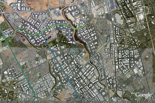
Sunday, May 3, 2009

Sunday Night Photo Dump II

Los Angeles TOD along the Gold Line at Mission Meridian and Del Mar Stations. It was a pretty hot day and I needed to catch an airplane but here's what I got...

Del Mar Station is the one where the train goes underneath the Apartments designed by Moule Polyzoides.

Pasadena Del Mar Station TOD

Pasadena Del Mar Station TOD

Bike Parking!

Del Mar Bike Station

Pasadena Cares about Alternative Transportation and Health

Del Mar Bike Station

Pasadena Del Mar Station TOD

Hot Day at Mission Meridian Station, could have used some Ice Cream from this place:

Mission Meridian TOD

Mission Meridian TOD

Connectivity to the bus is key...

Mission Meridian TOD

Mission Meridian TOD

Mission Meridian TOD

Anyone wonder why they need a subway on Wilshire?

Los Angeles Aerial Photos

Los Angeles Aerial Photos

Los Angeles Aerial Photos

Finally, there are a few videos. Two from Del Mar and one from the Police car that they kept running while they were checking tickets on the Mission Station Platform. What a waste of taxpayer dollars!!!